Rinchnach geodata
Rinchnach (Bavaria) is a seat of a fourth-order administrative division; located in Germany in Europe/Berlin (GMT+2) time zone. With population of 3,348 people, there are 3725 cities with bigger population in this country. Compared to other cities in Germany, 83.5% of cities are located further ↑North; 93.7% of cities are located further ←West and 93.5% of cities have lower elevation than Rinchnach. Note1
Administrative division(s):
- Level 1: Bavaria
- Level 2: Lower Bavaria
- Level 3: Landkreis Regen
- Level 4: Rinchnach


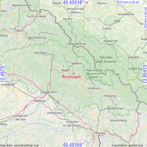
Rinchnach GPS coordinates[2]
48° 56' 58.416" North, 13° 12' 3.672" East
| Map corner | latitude | longitude |
|---|---|---|
| Upper-left | 49.40918°, | 12.4979° |
| Center: | 48.94956°, | 13.20102° |
| Lower-right: | 48.48566°, | 13.90415° |
| Map W x H: | 102.7×102.7 km | = 63.8×63.8mi |
| max Lat: | 55.01917° ⇑83.5% North |
| Rinchnach: | 48.94956° |
| min Lat: | ⇓16.5% South 47.40724° |
| min Long | Rinchnach | max Long |
| 5.92978° | 13.20102° | 14.98853° |
| W 93.7%⇐ | ⇒6.3% E |
Elevation
Elevation of Rinchnach is 566 m = 1857 ft, and this is 316.9 m = 1040 ft above average elevation for this country.
| Max E: |
1256 m = 4121 ft | 6.5% |
| Rinchnach | 566 m 1857 ft | |
| Avg. | 249.1 m = 817 ft | |
Min E: |
-5 m = -16 ft | 93.5% |
See also: Germany elevation on elevation.city.
Geographical zone
Rinchnach is located in North temperate zone (between Tropic of Cancer and the Arctic Circle). Distance of this North polar circle is 1958.5 km =1217 mi to North.| Distance of | km | miles | from Rinchnach |
|---|---|---|---|
| North Pole | 4564.4 | 2836.2 | to North |
| Arctic Circle | 1958.5 | 1217 | to North |
| Tropic Cancer | 2836.8 | 1762.7 | to South |
| Equator | 5442.7 | 3381.9 | to South |


Nearby cities:
15 places around Rinchnach: (largest is in red/bold)
• Bischofsmais
9.4 km =5.8 mi,  248°
248°
• Eppenschlag
9.8 km =6.1 mi,  132°
132°
• Frauenau
8.5 km =5.3 mi,  58°
58°
• Hunding
12.1 km =7.5 mi,  188°
188°
• Innernzell
12.2 km =7.6 mi,  153°
153°
• Kirchberg
5.7 km =3.5 mi, 194°
• Kirchdorf im Wald
6.4 km =4 mi, 132°
• Lalling
12.4 km =7.7 mi,  201°
201°
• Langdorf
8.3 km =5.2 mi,  331°
331°
• Lindberg
10.4 km =6.5 mi,  21°
21°
• Regen
5.9 km =3.7 mi,  295°
295°
• Schaufling
14.8 km =9.2 mi,  221°
221°
• Schöfweg
12.5 km =7.8 mi,  170°
170°
• Spiegelau
12.4 km =7.7 mi,  107°
107°
• Zwiesel
8 km =5 mi, 19°
Sources, notices
• [Note1] Compared only with cities in Germany existing in our database
• [Src1] Map data: © OpenStreetMap contributors (CC-BY-SA)
• [Src2] Other city data from geonames.org with taken over terms of usage.
• [Src3] Geographical zone / Annual Mean Temperature by Robert A. Rohde @ Wikipedia
