Räckelwitz geodata
Räckelwitz (Saxony) is a seat of a fourth-order administrative division; located in Germany in Europe/Berlin (GMT+2) time zone. With population of 1,216 people, there are 6520 cities with bigger population in this country. Compared to other cities in Germany, 62.3% of cities are located further ↓South; 98.7% of cities are located further ←West and 59.8% of cities have higher elevation than Räckelwitz. Note1


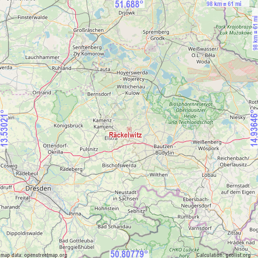
Räckelwitz GPS coordinates[2]
51° 15' 0" North, 14° 13' 59.988" East
| Map corner | latitude | longitude |
|---|---|---|
| Upper-left | 51.688°, | 13.53021° |
| Center: | 51.25°, | 14.23333° |
| Lower-right: | 50.80779°, | 14.93646° |
| Map W x H: | 97.9×97.9 km | = 60.8×60.8mi |
| max Lat: | 55.01917° ⇑37.7% North |
| Räckelwitz: | 51.25° |
| min Lat: | ⇓62.3% South 47.40724° |
| min Long | Räckelwitz | max Long |
| 5.92978° | 14.23333° | 14.98853° |
| W 98.7%⇐ | ⇒1.3% E |
Elevation
Elevation of Räckelwitz is 154 m = 505 ft, and this is 95.1 m = 312 ft below average elevation for this country.
| Max E: |
1256 m = 4121 ft | 59.8% |
| Avg. | 249.1 m = 817 ft | |
| Räckelwitz | 154 m = 505 ft | |
Min E: |
-5 m = -16 ft | 40.2% |
See also: Germany elevation on elevation.city.
Geographical zone
Räckelwitz is located in North temperate zone (between Tropic of Cancer and the Arctic Circle). Distance of this North polar circle is 1702.7 km =1058 mi to North.| Distance of | km | miles | from Räckelwitz |
|---|---|---|---|
| North Pole | 4308.6 | 2677.2 | to North |
| Arctic Circle | 1702.7 | 1058 | to North |
| Tropic Cancer | 3092.5 | 1921.6 | to South |
| Equator | 5698.5 | 3540.9 | to South |


Nearby cities:
15 places around Räckelwitz: (largest is in red/bold)
• Burkau
9.3 km =5.8 mi,  206°
206°
• Crostwitz
1.5 km =0.9 mi,  151°
151°
• Demitz-Thumitz
12.1 km =7.5 mi,  175°
175°
• Elstra
7.7 km =4.8 mi,  245°
245°
• Göda
10 km =6.2 mi,  143°
143°
• Horka
2.1 km =1.3 mi,  45°
45°
• Kamenz
9.9 km =6.2 mi,  281°
281°
• Königswartha
9.4 km =5.8 mi,  44°
44°
• Nebelschütz
5.4 km =3.4 mi, 284°
• Neschwitz
7 km =4.3 mi,  71°
71°
• Oßling
13.1 km =8.1 mi,  338°
338°
• Panschwitz-Kuckau
3 km =1.9 mi,  234°
234°
• Puschwitz
4.7 km =2.9 mi,  83°
83°
• Radibor
11.5 km =7.1 mi,  92°
92°
• Rammenau
13.1 km =8.1 mi, 212°
Sources, notices
• [Note1] Compared only with cities in Germany existing in our database
• [Src1] Map data: © OpenStreetMap contributors (CC-BY-SA)
• [Src2] Other city data from geonames.org with taken over terms of usage.
• [Src3] Geographical zone / Annual Mean Temperature by Robert A. Rohde @ Wikipedia
