Bad Liebenwerda geodata
Bad Liebenwerda (Brandenburg) is a populated place; located in Germany in Europe/Berlin (GMT+2) time zone. With population of 10,890 people, there are 1514 cities with bigger population in this country. Compared to other cities in Germany, 66.5% of cities are located further ↓South; 95% of cities are located further ←West and 70.4% of cities have higher elevation than Bad Liebenwerda. Note1
Administrative division(s):
- Level 1: Brandenburg
- Level 3: Landkreis Elbe-Elster
- Level 4: Bad Liebenwerda


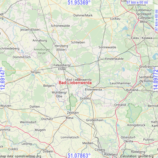
Bad Liebenwerda GPS coordinates[2]
51° 31' 5.736" North, 13° 23' 40.524" East
| Map corner | latitude | longitude |
|---|---|---|
| Upper-left | 51.95369°, | 12.69147° |
| Center: | 51.51826°, | 13.39459° |
| Lower-right: | 51.07863°, | 14.09772° |
| Map W x H: | 97.3×97.3 km | = 60.5×60.5mi |
| max Lat: | 55.01917° ⇑33.5% North |
| Bad Liebenwerda: | 51.51826° |
| min Lat: | ⇓66.5% South 47.40724° |
| min Long | Bad Liebenwerda | max Long |
| 5.92978° | 13.39459° | 14.98853° |
| W 95%⇐ | ⇒5% E |
Elevation
Elevation of Bad Liebenwerda is 89 m = 292 ft, and this is 160.1 m = 525 ft below average elevation for this country.
| Max E: |
1256 m = 4121 ft | 70.4% |
| Avg. | 249.1 m = 817 ft | |
| Bad Liebenwerda | 89 m = 292 ft | |
Min E: |
-5 m = -16 ft | 29.6% |
See also: Germany elevation on elevation.city.
Geographical zone
Bad Liebenwerda is located in North temperate zone (between Tropic of Cancer and the Arctic Circle). Distance of this North polar circle is 1672.9 km =1039.5 mi to North.| Distance of | km | miles | from Bad Liebenwerda |
|---|---|---|---|
| North Pole | 4278.8 | 2658.7 | to North |
| Arctic Circle | 1672.9 | 1039.5 | to North |
| Tropic Cancer | 3122.4 | 1940.2 | to South |
| Equator | 5728.3 | 3559.4 | to South |


Nearby cities:
15 places around Bad Liebenwerda: (largest is in red/bold)
• Doberlug-Kirchhain
16.7 km =10.4 mi,  44°
44°
• Elsterwerda
10.8 km =6.7 mi,  126°
126°
• Falkenberg
12.9 km =8 mi,  305°
305°
• Gröden
17.7 km =11 mi,  137°
137°
• Hohenleipisch
10.9 km =6.8 mi,  100°
100°
• Merzdorf
16.3 km =10.1 mi, 143°
• Mühlberg
15.2 km =9.4 mi,  232°
232°
• Nauwalde
11.2 km =7 mi,  174°
174°
• Plessa
16.4 km =10.2 mi,  110°
110°
• Rückersdorf
13.5 km =8.4 mi,  65°
65°
• Schilda
9.1 km =5.7 mi,  355°
355°
• Schönborn
11.2 km =7 mi, 35°
• Tröbitz
9.5 km =5.9 mi,  16°
16°
• Uebigau
10.7 km =6.6 mi,  322°
322°
• Wülknitz
16.9 km =10.5 mi,  178°
178°
Sources, notices
• [Note1] Compared only with cities in Germany existing in our database
• [Src1] Map data: © OpenStreetMap contributors (CC-BY-SA)
• [Src2] Other city data from geonames.org with taken over terms of usage.
• [Src3] Geographical zone / Annual Mean Temperature by Robert A. Rohde @ Wikipedia
