Elsendorf geodata
Elsendorf (Bavaria) is a seat of a fourth-order administrative division; located in Germany in Europe/Berlin (GMT+2) time zone. With population of 2,073 people, there are 4966 cities with bigger population in this country. Compared to other cities in Germany, 86.4% of cities are located further ↑North; 79% of cities are located further ←West and 75.6% of cities have lower elevation than Elsendorf. Note1
Administrative division(s):
- Level 1: Bavaria
- Level 2: Lower Bavaria
- Level 3: Landkreis Kelheim
- Level 4: Elsendorf


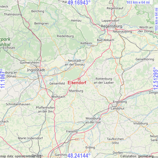
Elsendorf GPS coordinates[2]
48° 42' 27.252" North, 11° 48' 35.352" East
| Map corner | latitude | longitude |
|---|---|---|
| Upper-left | 49.16943°, | 11.1067° |
| Center: | 48.70757°, | 11.80982° |
| Lower-right: | 48.24144°, | 12.51295° |
| Map W x H: | 103.2×103.2 km | = 64.1×64.1mi |
| max Lat: | 55.01917° ⇑86.4% North |
| Elsendorf: | 48.70757° |
| min Lat: | ⇓13.6% South 47.40724° |
| min Long | Elsendorf | max Long |
| 5.92978° | 11.80982° | 14.98853° |
| W 79%⇐ | ⇒21% E |
Elevation
Elevation of Elsendorf is 402 m = 1319 ft, and this is 152.9 m = 502 ft above average elevation for this country.
| Max E: |
1256 m = 4121 ft | 24.4% |
| Elsendorf | 402 m 1319 ft | |
| Avg. | 249.1 m = 817 ft | |
Min E: |
-5 m = -16 ft | 75.6% |
See also: Germany elevation on elevation.city.
Geographical zone
Elsendorf is located in North temperate zone (between Tropic of Cancer and the Arctic Circle). Distance of this North polar circle is 1985.4 km =1233.7 mi to North.| Distance of | km | miles | from Elsendorf |
|---|---|---|---|
| North Pole | 4591.3 | 2852.9 | to North |
| Arctic Circle | 1985.4 | 1233.7 | to North |
| Tropic Cancer | 2809.9 | 1746 | to South |
| Equator | 5415.8 | 3365.2 | to South |


Nearby cities:
15 places around Elsendorf: (largest is in red/bold)
• Abensberg
12.5 km =7.8 mi,  13°
13°
• Aiglsbach
7.6 km =4.7 mi,  257°
257°
• Attenhofen
6.9 km =4.3 mi,  155°
155°
• Biburg
9.9 km =6.2 mi,  20°
20°
• Kirchdorf
9.9 km =6.2 mi,  44°
44°
• Kirchdorf
13.3 km =8.3 mi,  194°
194°
• Mainburg
7.6 km =4.7 mi,  196°
196°
• Münchsmünster
11.4 km =7.1 mi,  305°
305°
• Neustadt an der Donau
11.4 km =7.1 mi,  345°
345°
• Pfeffenhausen
12.4 km =7.7 mi,  112°
112°
• Rudelzhausen
12.4 km =7.7 mi, 194°
• Siegenburg
5.9 km =3.7 mi,  28°
28°
• Train
3.3 km =2.1 mi, 31°
• Volkenschwand
13.1 km =8.1 mi, 155°
• Wildenberg
7 km =4.3 mi,  69°
69°
Sources, notices
• [Note1] Compared only with cities in Germany existing in our database
• [Src1] Map data: © OpenStreetMap contributors (CC-BY-SA)
• [Src2] Other city data from geonames.org with taken over terms of usage.
• [Src3] Geographical zone / Annual Mean Temperature by Robert A. Rohde @ Wikipedia
