Attenhofen geodata
Attenhofen (Bavaria) is a seat of a fourth-order administrative division; located in Germany in Europe/Berlin (GMT+2) time zone. With population of 1,352 people, there are 6177 cities with bigger population in this country. Compared to other cities in Germany, 87.1% of cities are located further ↑North; 79.5% of cities are located further ←West and 83.6% of cities have lower elevation than Attenhofen. Note1
Administrative division(s):
- Level 1: Bavaria
- Level 2: Lower Bavaria
- Level 3: Landkreis Kelheim
- Level 4: Attenhofen


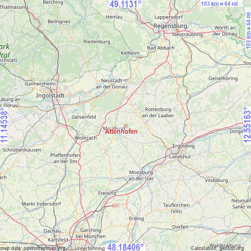
Attenhofen GPS coordinates[2]
48° 39' 2.592" North, 11° 50' 54.6" East
| Map corner | latitude | longitude |
|---|---|---|
| Upper-left | 49.1131°, | 11.14538° |
| Center: | 48.65072°, | 11.8485° |
| Lower-right: | 48.18406°, | 12.55163° |
| Map W x H: | 103.3×103.3 km | = 64.2×64.2mi |
| max Lat: | 55.01917° ⇑87.1% North |
| Attenhofen: | 48.65072° |
| min Lat: | ⇓12.9% South 47.40724° |
| min Long | Attenhofen | max Long |
| 5.92978° | 11.8485° | 14.98853° |
| W 79.5%⇐ | ⇒20.5% E |
Elevation
Elevation of Attenhofen is 458 m = 1503 ft, and this is 208.9 m = 685 ft above average elevation for this country.
| Max E: |
1256 m = 4121 ft | 16.4% |
| Attenhofen | 458 m 1503 ft | |
| Avg. | 249.1 m = 817 ft | |
Min E: |
-5 m = -16 ft | 83.6% |
See also: Germany elevation on elevation.city.
Geographical zone
Attenhofen is located in North temperate zone (between Tropic of Cancer and the Arctic Circle). Distance of this North polar circle is 1991.7 km =1237.6 mi to North.| Distance of | km | miles | from Attenhofen |
|---|---|---|---|
| North Pole | 4597.6 | 2856.8 | to North |
| Arctic Circle | 1991.7 | 1237.6 | to North |
| Tropic Cancer | 2803.5 | 1742 | to South |
| Equator | 5409.5 | 3361.3 | to South |


Nearby cities:
15 places around Attenhofen: (largest is in red/bold)
• Aiglsbach
11.3 km =7 mi,  294°
294°
• Au in der Hallertau
12.9 km =8 mi,  217°
217°
• Elsendorf
6.9 km =4.3 mi,  335°
335°
• Gammelsdorf
13.5 km =8.4 mi,  146°
146°
• Hörgertshausen
11.3 km =7 mi,  173°
173°
• Kirchdorf
9 km =5.6 mi, 223°
• Mainburg
5.1 km =3.2 mi,  258°
258°
• Nandlstadt
13.1 km =8.1 mi,  193°
193°
• Obersüßbach
8.4 km =5.2 mi,  116°
116°
• Pfeffenhausen
8.8 km =5.5 mi,  79°
79°
• Rudelzhausen
8.2 km =5.1 mi,  226°
226°
• Siegenburg
11.5 km =7.1 mi,  359°
359°
• Train
9.3 km =5.8 mi,  353°
353°
• Volkenschwand
6.2 km =3.9 mi,  155°
155°
• Wildenberg
9.5 km =5.9 mi,  22°
22°
Sources, notices
• [Note1] Compared only with cities in Germany existing in our database
• [Src1] Map data: © OpenStreetMap contributors (CC-BY-SA)
• [Src2] Other city data from geonames.org with taken over terms of usage.
• [Src3] Geographical zone / Annual Mean Temperature by Robert A. Rohde @ Wikipedia
