Aiglsbach geodata
Aiglsbach (Bavaria) is a seat of a fourth-order administrative division; located in Germany in Europe/Berlin (GMT+2) time zone. With population of 1,677 people, there are 5557 cities with bigger population in this country. Compared to other cities in Germany, 86.6% of cities are located further ↑North; 77.3% of cities are located further ←West and 76.8% of cities have lower elevation than Aiglsbach. Note1
Administrative division(s):
- Level 1: Bavaria
- Level 2: Lower Bavaria
- Level 3: Landkreis Kelheim
- Level 4: Aiglsbach


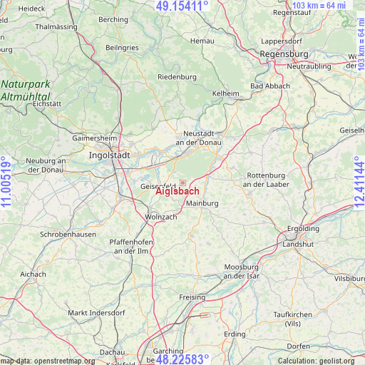
Aiglsbach GPS coordinates[2]
48° 41' 31.596" North, 11° 42' 29.916" East
| Map corner | latitude | longitude |
|---|---|---|
| Upper-left | 49.15411°, | 11.00519° |
| Center: | 48.69211°, | 11.70831° |
| Lower-right: | 48.22583°, | 12.41144° |
| Map W x H: | 103.2×103.2 km | = 64.1×64.1mi |
| max Lat: | 55.01917° ⇑86.6% North |
| Aiglsbach: | 48.69211° |
| min Lat: | ⇓13.4% South 47.40724° |
| min Long | Aiglsbach | max Long |
| 5.92978° | 11.70831° | 14.98853° |
| W 77.3%⇐ | ⇒22.7% E |
Elevation
Elevation of Aiglsbach is 411 m = 1348 ft, and this is 161.9 m = 531 ft above average elevation for this country.
| Max E: |
1256 m = 4121 ft | 23.2% |
| Aiglsbach | 411 m 1348 ft | |
| Avg. | 249.1 m = 817 ft | |
Min E: |
-5 m = -16 ft | 76.8% |
See also: Germany elevation on elevation.city.
Geographical zone
Aiglsbach is located in North temperate zone (between Tropic of Cancer and the Arctic Circle). Distance of this North polar circle is 1987.1 km =1234.7 mi to North.| Distance of | km | miles | from Aiglsbach |
|---|---|---|---|
| North Pole | 4593 | 2854 | to North |
| Arctic Circle | 1987.1 | 1234.7 | to North |
| Tropic Cancer | 2808.1 | 1744.9 | to South |
| Equator | 5414.1 | 3364.2 | to South |


Nearby cities:
15 places around Aiglsbach: (largest is in red/bold)
• Attenhofen
11.3 km =7 mi,  114°
114°
• Elsendorf
7.6 km =4.7 mi,  77°
77°
• Ernsgaden
10.3 km =6.4 mi,  296°
296°
• Geisenfeld
7.1 km =4.4 mi,  262°
262°
• Kirchdorf
11.9 km =7.4 mi,  159°
159°
• Mainburg
7.7 km =4.8 mi,  136°
136°
• Münchsmünster
8.5 km =5.3 mi,  347°
347°
• Neustadt an der Donau
13.5 km =8.4 mi,  19°
19°
• Rohrbach
13.4 km =8.3 mi,  231°
231°
• Rudelzhausen
11.1 km =6.9 mi, 157°
• Siegenburg
12.4 km =7.7 mi,  56°
56°
• Train
10.3 km =6.4 mi, 63°
• Vohburg an der Donau
10.9 km =6.8 mi,  322°
322°
• Wildenberg
14.6 km =9.1 mi,  73°
73°
• Wolnzach
11.5 km =7.1 mi,  211°
211°
Sources, notices
• [Note1] Compared only with cities in Germany existing in our database
• [Src1] Map data: © OpenStreetMap contributors (CC-BY-SA)
• [Src2] Other city data from geonames.org with taken over terms of usage.
• [Src3] Geographical zone / Annual Mean Temperature by Robert A. Rohde @ Wikipedia
