Pfeffenhausen geodata
Pfeffenhausen (Bavaria) is a populated place; located in Germany in Europe/Berlin (GMT+2) time zone. With population of 4,770 people, there are 2912 cities with bigger population in this country. Compared to other cities in Germany, 87% of cities are located further ↑North; 81.4% of cities are located further ←West and 81% of cities have lower elevation than Pfeffenhausen. Note1
Administrative division(s):
- Level 1: Bavaria
- Level 2: Lower Bavaria
- Level 3: Landkreis Landshut
- Level 4: Pfeffenhausen, Markt


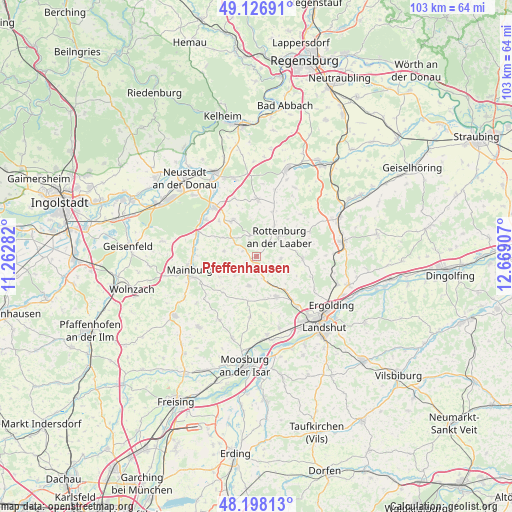
Pfeffenhausen GPS coordinates[2]
48° 39' 52.776" North, 11° 57' 57.384" East
| Map corner | latitude | longitude |
|---|---|---|
| Upper-left | 49.12691°, | 11.26282° |
| Center: | 48.66466°, | 11.96594° |
| Lower-right: | 48.19813°, | 12.66907° |
| Map W x H: | 103.3×103.3 km | = 64.2×64.2mi |
| max Lat: | 55.01917° ⇑87% North |
| Pfeffenhausen: | 48.66466° |
| min Lat: | ⇓13% South 47.40724° |
| min Long | Pfeffenhausen | max Long |
| 5.92978° | 11.96594° | 14.98853° |
| W 81.4%⇐ | ⇒18.6% E |
Elevation
Elevation of Pfeffenhausen is 440 m = 1444 ft, and this is 190.9 m = 626 ft above average elevation for this country.
| Max E: |
1256 m = 4121 ft | 19% |
| Pfeffenhausen | 440 m 1444 ft | |
| Avg. | 249.1 m = 817 ft | |
Min E: |
-5 m = -16 ft | 81% |
See also: Germany elevation on elevation.city.
Geographical zone
Pfeffenhausen is located in North temperate zone (between Tropic of Cancer and the Arctic Circle). Distance of this North polar circle is 1990.2 km =1236.7 mi to North.| Distance of | km | miles | from Pfeffenhausen |
|---|---|---|---|
| North Pole | 4596.1 | 2855.9 | to North |
| Arctic Circle | 1990.2 | 1236.7 | to North |
| Tropic Cancer | 2805.1 | 1743 | to South |
| Equator | 5411 | 3362.2 | to South |


Nearby cities:
15 places around Pfeffenhausen: (largest is in red/bold)
• Attenhofen
8.8 km =5.5 mi,  259°
259°
• Elsendorf
12.4 km =7.7 mi,  292°
292°
• Furth
9.1 km =5.7 mi,  153°
153°
• Gammelsdorf
12.8 km =8 mi,  185°
185°
• Hohenthann
9.3 km =5.8 mi,  92°
92°
• Kirchdorf
12.7 km =7.9 mi,  338°
338°
• Mainburg
13.8 km =8.6 mi, 259°
• Obersüßbach
5.5 km =3.4 mi, 192°
• Rohr
11.5 km =7.1 mi,  2°
2°
• Rottenburg an der Laaber
6.1 km =3.8 mi,  47°
47°
• Siegenburg
13.2 km =8.2 mi,  319°
319°
• Train
12.4 km =7.7 mi,  308°
308°
• Volkenschwand
9.4 km =5.8 mi,  220°
220°
• Weihmichl
9.5 km =5.9 mi,  139°
139°
• Wildenberg
8.8 km =5.5 mi,  325°
325°
Sources, notices
• [Note1] Compared only with cities in Germany existing in our database
• [Src1] Map data: © OpenStreetMap contributors (CC-BY-SA)
• [Src2] Other city data from geonames.org with taken over terms of usage.
• [Src3] Geographical zone / Annual Mean Temperature by Robert A. Rohde @ Wikipedia
