Siegenburg geodata
Siegenburg (Bavaria) is a populated place; located in Germany in Europe/Berlin (GMT+2) time zone. With population of 3,376 people, there are 3699 cities with bigger population in this country. Compared to other cities in Germany, 85.8% of cities are located further ↑North; 79.4% of cities are located further ←West and 74.4% of cities have lower elevation than Siegenburg. Note1
Administrative division(s):
- Level 1: Bavaria
- Level 2: Lower Bavaria
- Level 3: Landkreis Kelheim
- Level 4: Siegenburg, Markt


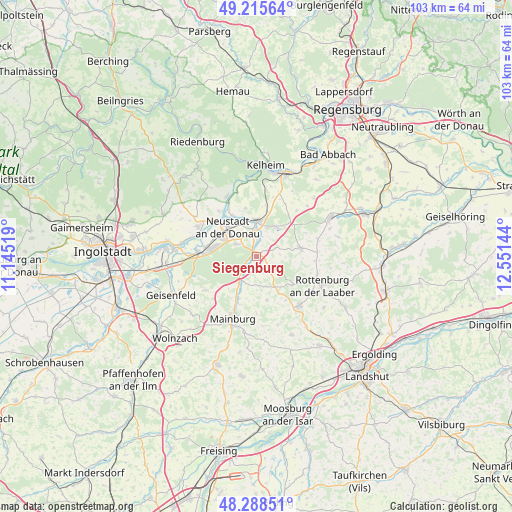
Siegenburg GPS coordinates[2]
48° 45' 15.156" North, 11° 50' 53.916" East
| Map corner | latitude | longitude |
|---|---|---|
| Upper-left | 49.21564°, | 11.14519° |
| Center: | 48.75421°, | 11.84831° |
| Lower-right: | 48.28851°, | 12.55144° |
| Map W x H: | 103.1×103.1 km | = 64.1×64.1mi |
| max Lat: | 55.01917° ⇑85.8% North |
| Siegenburg: | 48.75421° |
| min Lat: | ⇓14.2% South 47.40724° |
| min Long | Siegenburg | max Long |
| 5.92978° | 11.84831° | 14.98853° |
| W 79.4%⇐ | ⇒20.6% E |
Elevation
Elevation of Siegenburg is 393 m = 1289 ft, and this is 143.9 m = 472 ft above average elevation for this country.
| Max E: |
1256 m = 4121 ft | 25.6% |
| Siegenburg | 393 m 1289 ft | |
| Avg. | 249.1 m = 817 ft | |
Min E: |
-5 m = -16 ft | 74.4% |
See also: Germany elevation on elevation.city.
Geographical zone
Siegenburg is located in North temperate zone (between Tropic of Cancer and the Arctic Circle). Distance of this North polar circle is 1980.2 km =1230.4 mi to North.| Distance of | km | miles | from Siegenburg |
|---|---|---|---|
| North Pole | 4586.1 | 2849.7 | to North |
| Arctic Circle | 1980.2 | 1230.4 | to North |
| Tropic Cancer | 2815 | 1749.2 | to South |
| Equator | 5421 | 3368.5 | to South |


Nearby cities:
15 places around Siegenburg: (largest is in red/bold)
• Abensberg
7 km =4.3 mi,  0°
0°
• Aiglsbach
12.4 km =7.7 mi,  236°
236°
• Attenhofen
11.5 km =7.1 mi,  179°
179°
• Biburg
4.1 km =2.5 mi,  9°
9°
• Elsendorf
5.9 km =3.7 mi,  208°
208°
• Hausen
16.5 km =10.3 mi,  44°
44°
• Kirchdorf
4.5 km =2.8 mi,  65°
65°
• Mainburg
13.4 km =8.3 mi,  201°
201°
• Münchsmünster
12.2 km =7.6 mi,  276°
276°
• Neustadt an der Donau
8.2 km =5.1 mi,  315°
315°
• Pfeffenhausen
13.2 km =8.2 mi,  139°
139°
• Rohr
9.2 km =5.7 mi,  80°
80°
• Rottenburg an der Laaber
14.3 km =8.9 mi,  113°
113°
• Train
2.6 km =1.6 mi, 205°
• Wildenberg
4.6 km =2.9 mi,  126°
126°
Sources, notices
• [Note1] Compared only with cities in Germany existing in our database
• [Src1] Map data: © OpenStreetMap contributors (CC-BY-SA)
• [Src2] Other city data from geonames.org with taken over terms of usage.
• [Src3] Geographical zone / Annual Mean Temperature by Robert A. Rohde @ Wikipedia
