Rudelzhausen geodata
Rudelzhausen (Bavaria) is a seat of a fourth-order administrative division; located in Germany in Europe/Berlin (GMT+2) time zone. With population of 3,114 people, there are 3907 cities with bigger population in this country. Compared to other cities in Germany, 87.8% of cities are located further ↑North; 78.3% of cities are located further ←West and 84.1% of cities have lower elevation than Rudelzhausen. Note1
Administrative division(s):
- Level 1: Bavaria
- Level 2: Upper Bavaria
- Level 3: Landkreis Freising
- Level 4: Rudelzhausen


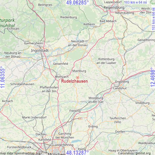
Rudelzhausen GPS coordinates[2]
48° 36' 0" North, 11° 46' 0.012" East
| Map corner | latitude | longitude |
|---|---|---|
| Upper-left | 49.06285°, | 11.06355° |
| Center: | 48.6°, | 11.76667° |
| Lower-right: | 48.13287°, | 12.4698° |
| Map W x H: | 103.4×103.4 km | = 64.2×64.2mi |
| max Lat: | 55.01917° ⇑87.8% North |
| Rudelzhausen: | 48.6° |
| min Lat: | ⇓12.2% South 47.40724° |
| min Long | Rudelzhausen | max Long |
| 5.92978° | 11.76667° | 14.98853° |
| W 78.3%⇐ | ⇒21.7% E |
Elevation
Elevation of Rudelzhausen is 462 m = 1516 ft, and this is 212.9 m = 698 ft above average elevation for this country.
| Max E: |
1256 m = 4121 ft | 15.9% |
| Rudelzhausen | 462 m 1516 ft | |
| Avg. | 249.1 m = 817 ft | |
Min E: |
-5 m = -16 ft | 84.1% |
See also: Germany elevation on elevation.city.
Geographical zone
Rudelzhausen is located in North temperate zone (between Tropic of Cancer and the Arctic Circle). Distance of this North polar circle is 1997.4 km =1241.1 mi to North.| Distance of | km | miles | from Rudelzhausen |
|---|---|---|---|
| North Pole | 4603.2 | 2860.3 | to North |
| Arctic Circle | 1997.4 | 1241.1 | to North |
| Tropic Cancer | 2797.9 | 1738.5 | to South |
| Equator | 5403.8 | 3357.8 | to South |


Nearby cities:
15 places around Rudelzhausen: (largest is in red/bold)
• Aiglsbach
11.1 km =6.9 mi,  337°
337°
• Attenhofen
8.2 km =5.1 mi,  46°
46°
• Attenkirchen
10.5 km =6.5 mi,  182°
182°
• Au in der Hallertau
5 km =3.1 mi,  201°
201°
• Elsendorf
12.4 km =7.7 mi,  14°
14°
• Gammelsdorf
14.6 km =9.1 mi,  112°
112°
• Hörgertshausen
9.2 km =5.7 mi,  127°
127°
• Kirchdorf
0.9 km =0.6 mi,  192°
192°
• Mainburg
4.8 km =3 mi, 12°
• Mauern
13.5 km =8.4 mi, 133°
• Nandlstadt
7.7 km =4.8 mi,  157°
157°
• Obersüßbach
13.6 km =8.5 mi,  82°
82°
• Volkenschwand
8.6 km =5.3 mi,  90°
90°
• Wolfersdorf
14.1 km =8.8 mi, 197°
• Wolnzach
10.4 km =6.5 mi,  272°
272°
Sources, notices
• [Note1] Compared only with cities in Germany existing in our database
• [Src1] Map data: © OpenStreetMap contributors (CC-BY-SA)
• [Src2] Other city data from geonames.org with taken over terms of usage.
• [Src3] Geographical zone / Annual Mean Temperature by Robert A. Rohde @ Wikipedia
