Dassel geodata
Dassel (Lower Saxony) is a populated place; located in Germany in Europe/Berlin (GMT+2) time zone. With population of 11,287 people, there are 1465 cities with bigger population in this country. Compared to other cities in Germany, 70% of cities are located further ↓South; 54.5% of cities are located further →East and 57.5% of cities have higher elevation than Dassel. Note1


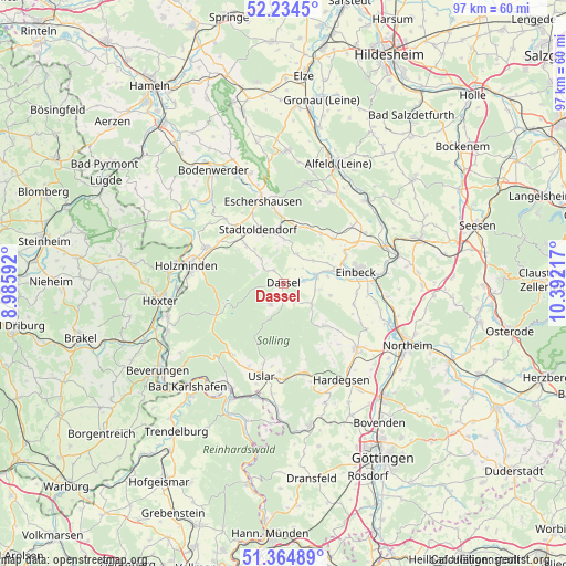
Dassel GPS coordinates[2]
51° 48' 6.444" North, 9° 41' 20.544" East
| Map corner | latitude | longitude |
|---|---|---|
| Upper-left | 52.2345°, | 8.98592° |
| Center: | 51.80179°, | 9.68904° |
| Lower-right: | 51.36489°, | 10.39217° |
| Map W x H: | 96.7×96.7 km | = 60.1×60.1mi |
| max Lat: | 55.01917° ⇑30% North |
| Dassel: | 51.80179° |
| min Lat: | ⇓70% South 47.40724° |
| min Long | Dassel | max Long |
| 5.92978° | 9.68904° | 14.98853° |
| W 45.5%⇐ | ⇒54.5% E |
Elevation
Elevation of Dassel is 171 m = 561 ft, and this is 78.1 m = 256 ft below average elevation for this country.
| Max E: |
1256 m = 4121 ft | 57.5% |
| Avg. | 249.1 m = 817 ft | |
| Dassel | 171 m = 561 ft | |
Min E: |
-5 m = -16 ft | 42.5% |
See also: Germany elevation on elevation.city.
Geographical zone
Dassel is located in North temperate zone (between Tropic of Cancer and the Arctic Circle). Distance of this North polar circle is 1641.4 km =1019.9 mi to North.| Distance of | km | miles | from Dassel |
|---|---|---|---|
| North Pole | 4247.2 | 2639.1 | to North |
| Arctic Circle | 1641.4 | 1019.9 | to North |
| Tropic Cancer | 3153.9 | 1959.7 | to South |
| Equator | 5759.8 | 3579 | to South |


Nearby cities:
15 places around Dassel: (largest is in red/bold)
• Arholzen
11.1 km =6.9 mi,  310°
310°
• Bevern
14.8 km =9.2 mi,  295°
295°
• Deensen
9.3 km =5.8 mi, 314°
• Eimen
11.1 km =6.9 mi,  35°
35°
• Einbeck
12.6 km =7.8 mi,  80°
80°
• Eschershausen
14.2 km =8.8 mi,  347°
347°
• Golmbach
14.5 km =9 mi,  318°
318°
• Heinade
5.2 km =3.2 mi, 312°
• Holenberg
14.7 km =9.1 mi,  330°
330°
• Holzen
14.7 km =9.1 mi, 354°
• Lenne
10.2 km =6.3 mi,  357°
357°
• Negenborn
12.4 km =7.7 mi, 317°
• Stadtoldendorf
9.9 km =6.2 mi, 334°
• Uslar
16.5 km =10.3 mi,  193°
193°
• Wangelnstedt
7.2 km =4.5 mi, 356°
Sources, notices
• [Note1] Compared only with cities in Germany existing in our database
• [Src1] Map data: © OpenStreetMap contributors (CC-BY-SA)
• [Src2] Other city data from geonames.org with taken over terms of usage.
• [Src3] Geographical zone / Annual Mean Temperature by Robert A. Rohde @ Wikipedia
