Bispingen geodata
Bispingen (Lower Saxony) is a seat of a fourth-order administrative division; located in Germany in Europe/Berlin (GMT+2) time zone. With population of 6,284 people, there are 2371 cities with bigger population in this country. Compared to other cities in Germany, 82.2% of cities are located further ↓South; 50% of cities are located further ←West and 72% of cities have higher elevation than Bispingen. Note1


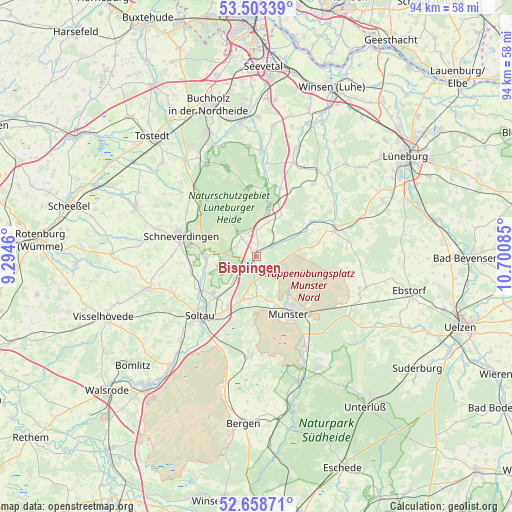
Bispingen GPS coordinates[2]
53° 4' 59.232" North, 9° 59' 51.792" East
| Map corner | latitude | longitude |
|---|---|---|
| Upper-left | 53.50339°, | 9.2946° |
| Center: | 53.08312°, | 9.99772° |
| Lower-right: | 52.65871°, | 10.70085° |
| Map W x H: | 93.9×93.9 km | = 58.3×58.3mi |
| max Lat: | 55.01917° ⇑17.8% North |
| Bispingen: | 53.08312° |
| min Lat: | ⇓82.2% South 47.40724° |
| min Long | Bispingen | max Long |
| 5.92978° | 9.99772° | 14.98853° |
| W 50%⇐ | ⇒50% E |
Elevation
Elevation of Bispingen is 78 m = 256 ft, and this is 171.1 m = 561 ft below average elevation for this country.
| Max E: |
1256 m = 4121 ft | 72% |
| Avg. | 249.1 m = 817 ft | |
| Bispingen | 78 m = 256 ft | |
Min E: |
-5 m = -16 ft | 28% |
See also: Germany elevation on elevation.city.
Geographical zone
Bispingen is located in North temperate zone (between Tropic of Cancer and the Arctic Circle). Distance of this North polar circle is 1498.9 km =931.4 mi to North.| Distance of | km | miles | from Bispingen |
|---|---|---|---|
| North Pole | 4104.8 | 2550.6 | to North |
| Arctic Circle | 1498.9 | 931.4 | to North |
| Tropic Cancer | 3296.4 | 2048.3 | to South |
| Equator | 5902.3 | 3667.5 | to South |


Nearby cities:
15 places around Bispingen: (largest is in red/bold)
• Amelinghausen
15.1 km =9.4 mi,  72°
72°
• Egestorf
13 km =8.1 mi,  19°
19°
• Eyendorf
16.5 km =10.3 mi,  38°
38°
• Garlstorf
18.5 km =11.5 mi, 21°
• Gödenstorf
18.2 km =11.3 mi,  27°
27°
• Munster
12.4 km =7.7 mi,  150°
150°
• Neuenkirchen
20.3 km =12.6 mi,  253°
253°
• Oldendorf
16.6 km =10.3 mi,  60°
60°
• Rehlingen
15.1 km =9.4 mi,  80°
80°
• Salzhausen
19.4 km =12.1 mi, 36°
• Schneverdingen
14 km =8.7 mi,  285°
285°
• Soderstorf
12 km =7.5 mi, 56°
• Soltau
14.9 km =9.3 mi,  223°
223°
• Undeloh
12.8 km =8 mi,  353°
353°
• Wietzendorf
18.5 km =11.5 mi,  182°
182°
Sources, notices
• [Note1] Compared only with cities in Germany existing in our database
• [Src1] Map data: © OpenStreetMap contributors (CC-BY-SA)
• [Src2] Other city data from geonames.org with taken over terms of usage.
• [Src3] Geographical zone / Annual Mean Temperature by Robert A. Rohde @ Wikipedia
