Soderstorf geodata
Soderstorf (Lower Saxony) is a seat of a fourth-order administrative division; located in Germany in Europe/Berlin (GMT+2) time zone. With population of 1,536 people, there are 5804 cities with bigger population in this country. Compared to other cities in Germany, 82.5% of cities are located further ↓South; 52.4% of cities are located further ←West and 77.3% of cities have higher elevation than Soderstorf. Note1


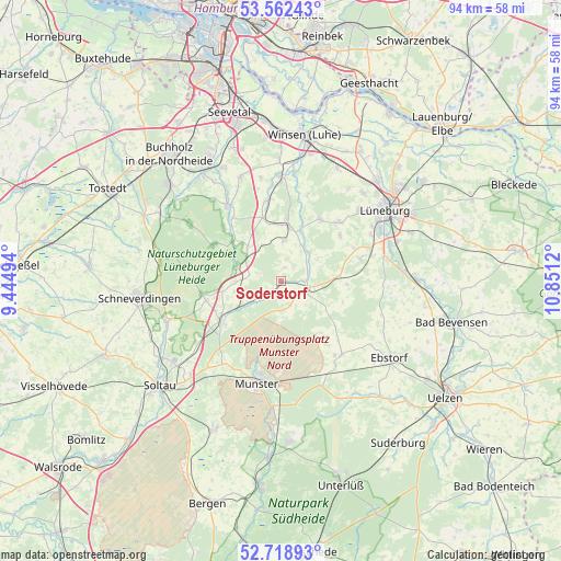
Soderstorf GPS coordinates[2]
53° 8' 33.9" North, 10° 8' 53.052" East
| Map corner | latitude | longitude |
|---|---|---|
| Upper-left | 53.56243°, | 9.44494° |
| Center: | 53.14275°, | 10.14807° |
| Lower-right: | 52.71893°, | 10.8512° |
| Map W x H: | 93.8×93.8 km | = 58.3×58.3mi |
| max Lat: | 55.01917° ⇑17.5% North |
| Soderstorf: | 53.14275° |
| min Lat: | ⇓82.5% South 47.40724° |
| min Long | Soderstorf | max Long |
| 5.92978° | 10.14807° | 14.98853° |
| W 52.4%⇐ | ⇒47.6% E |
Elevation
Elevation of Soderstorf is 55 m = 180 ft, and this is 194.1 m = 637 ft below average elevation for this country.
| Max E: |
1256 m = 4121 ft | 77.3% |
| Avg. | 249.1 m = 817 ft | |
| Soderstorf | 55 m = 180 ft | |
Min E: |
-5 m = -16 ft | 22.7% |
See also: Germany elevation on elevation.city.
Geographical zone
Soderstorf is located in North temperate zone (between Tropic of Cancer and the Arctic Circle). Distance of this North polar circle is 1492.3 km =927.3 mi to North.| Distance of | km | miles | from Soderstorf |
|---|---|---|---|
| North Pole | 4098.1 | 2546.4 | to North |
| Arctic Circle | 1492.3 | 927.3 | to North |
| Tropic Cancer | 3303 | 2052.4 | to South |
| Equator | 5908.9 | 3671.6 | to South |


Nearby cities:
15 places around Soderstorf: (largest is in red/bold)
• Amelinghausen
4.8 km =3 mi,  115°
115°
• Betzendorf
11 km =6.8 mi,  93°
93°
• Bispingen
12 km =7.5 mi,  236°
236°
• Egestorf
8 km =5 mi,  314°
314°
• Embsen
13.7 km =8.5 mi,  74°
74°
• Eyendorf
6.4 km =4 mi,  1°
1°
• Garlstorf
11 km =6.8 mi,  343°
343°
• Gödenstorf
9.7 km =6 mi,  350°
350°
• Oldendorf
4.6 km =2.9 mi, 71°
• Rehlingen
6.4 km =4 mi,  130°
130°
• Salzhausen
9.1 km =5.7 mi,  9°
9°
• Südergellersen
13 km =8.1 mi,  50°
50°
• Toppenstedt
13.7 km =8.5 mi, 350°
• Undeloh
13 km =8.1 mi,  297°
297°
• Westergellersen
12.1 km =7.5 mi,  33°
33°
Sources, notices
• [Note1] Compared only with cities in Germany existing in our database
• [Src1] Map data: © OpenStreetMap contributors (CC-BY-SA)
• [Src2] Other city data from geonames.org with taken over terms of usage.
• [Src3] Geographical zone / Annual Mean Temperature by Robert A. Rohde @ Wikipedia
