Eckersdorf geodata
Eckersdorf (Bavaria) is a seat of a fourth-order administrative division; located in Germany in Europe/Berlin (GMT+2) time zone. In our database, there are 11009 cities with bigger population. Compared to other cities in Germany, 65.4% of cities are located further ↑North; 74.2% of cities are located further ←West and 79.1% of cities have lower elevation than Eckersdorf. Note1
Administrative division(s):
- Level 1: Bavaria
- Level 2: Upper Franconia
- Level 3: Landkreis Bayreuth
- Level 4: Eckersdorf


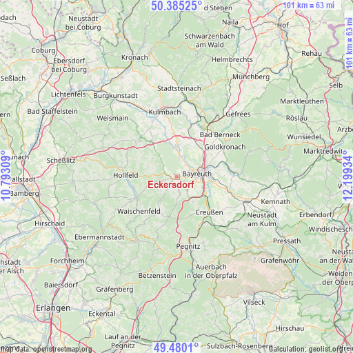
Eckersdorf GPS coordinates[2]
49° 56' 5.28" North, 11° 29' 46.356" East
| Map corner | latitude | longitude |
|---|---|---|
| Upper-left | 50.38525°, | 10.79309° |
| Center: | 49.9348°, | 11.49621° |
| Lower-right: | 49.4801°, | 12.19934° |
| Map W x H: | 100.6×100.6 km | = 62.5×62.5mi |
| max Lat: | 55.01917° ⇑65.4% North |
| Eckersdorf: | 49.9348° |
| min Lat: | ⇓34.6% South 47.40724° |
| min Long | Eckersdorf | max Long |
| 5.92978° | 11.49621° | 14.98853° |
| W 74.2%⇐ | ⇒25.8% E |
Elevation
Elevation of Eckersdorf is 428 m = 1404 ft, and this is 178.9 m = 587 ft above average elevation for this country.
| Max E: |
1256 m = 4121 ft | 20.9% |
| Eckersdorf | 428 m 1404 ft | |
| Avg. | 249.1 m = 817 ft | |
Min E: |
-5 m = -16 ft | 79.1% |
See also: Germany elevation on elevation.city.
Geographical zone
Eckersdorf is located in North temperate zone (between Tropic of Cancer and the Arctic Circle). Distance of this North polar circle is 1848.9 km =1148.9 mi to North.| Distance of | km | miles | from Eckersdorf |
|---|---|---|---|
| North Pole | 4454.8 | 2768.1 | to North |
| Arctic Circle | 1848.9 | 1148.9 | to North |
| Tropic Cancer | 2946.3 | 1830.7 | to South |
| Equator | 5552.2 | 3450 | to South |


Nearby cities:
15 places around Eckersdorf: (largest is in red/bold)
• Bayreuth
6.1 km =3.8 mi,  76°
76°
• Bindlach
9.9 km =6.2 mi,  58°
58°
• Eckersdorf
12.7 km =7.9 mi,  325°
325°
• Emtmannsberg
11.6 km =7.2 mi,  113°
113°
• Gesees
4.7 km =2.9 mi,  145°
145°
• Glashütten
6.3 km =3.9 mi,  212°
212°
• Haag
8.6 km =5.3 mi, 147°
• Harsdorf
12.1 km =7.5 mi,  24°
24°
• Heinersreuth
4.4 km =2.7 mi,  36°
36°
• Mistelbach
2.7 km =1.7 mi, 154°
• Mistelgau
3.3 km =2.1 mi,  221°
221°
• Neudrossenfeld
9.1 km =5.7 mi,  1°
1°
• Neunkirchen am Main
10.9 km =6.8 mi,  96°
96°
• Plankenfels
13 km =8.1 mi,  243°
243°
• Thurnau
12.5 km =7.8 mi,  323°
323°
Sources, notices
• [Note1] Compared only with cities in Germany existing in our database
• [Src1] Map data: © OpenStreetMap contributors (CC-BY-SA)
• [Src2] Other city data from geonames.org with taken over terms of usage.
• [Src3] Geographical zone / Annual Mean Temperature by Robert A. Rohde @ Wikipedia
