Großheringen geodata
Großheringen (Thuringia) is a seat of a fourth-order administrative division; located in Germany in Europe/Berlin (GMT+2) time zone. With population of 685 people, there are 8387 cities with bigger population in this country. Compared to other cities in Germany, 59.9% of cities are located further ↓South; 76.8% of cities are located further ←West and 64.1% of cities have higher elevation than Großheringen. Note1


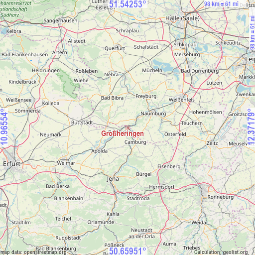
Großheringen GPS coordinates[2]
51° 6' 11.268" North, 11° 40' 7.176" East
| Map corner | latitude | longitude |
|---|---|---|
| Upper-left | 51.54253°, | 10.96554° |
| Center: | 51.10313°, | 11.66866° |
| Lower-right: | 50.65951°, | 12.37179° |
| Map W x H: | 98.2×98.2 km | = 61×61mi |
| max Lat: | 55.01917° ⇑40.1% North |
| Großheringen: | 51.10313° |
| min Lat: | ⇓59.9% South 47.40724° |
| min Long | Großheringen | max Long |
| 5.92978° | 11.66866° | 14.98853° |
| W 76.8%⇐ | ⇒23.2% E |
Elevation
Elevation of Großheringen is 126 m = 413 ft, and this is 123.1 m = 404 ft below average elevation for this country.
| Max E: |
1256 m = 4121 ft | 64.1% |
| Avg. | 249.1 m = 817 ft | |
| Großheringen | 126 m = 413 ft | |
Min E: |
-5 m = -16 ft | 35.9% |
See also: Germany elevation on elevation.city.
Geographical zone
Großheringen is located in North temperate zone (between Tropic of Cancer and the Arctic Circle). Distance of this North polar circle is 1719 km =1068.1 mi to North.| Distance of | km | miles | from Großheringen |
|---|---|---|---|
| North Pole | 4324.9 | 2687.4 | to North |
| Arctic Circle | 1719 | 1068.1 | to North |
| Tropic Cancer | 3076.2 | 1911.5 | to South |
| Equator | 5682.1 | 3530.7 | to South |


Nearby cities:
15 places around Großheringen: (largest is in red/bold)
• Bad Kösen
5.1 km =3.2 mi,  47°
47°
• Bad Sulza
3.4 km =2.1 mi,  243°
243°
• Camburg
6 km =3.7 mi,  151°
151°
• Eberstedt
7.1 km =4.4 mi, 242°
• Eckartsberga
7.9 km =4.9 mi,  286°
286°
• Frauenprießnitz
10.6 km =6.6 mi, 154°
• Klosterhäseler
7.8 km =4.8 mi,  329°
329°
• Lengefeld
3.4 km =2.1 mi,  64°
64°
• Molau
9.2 km =5.7 mi,  123°
123°
• Rannstedt
8.6 km =5.3 mi,  255°
255°
• Schmiedehausen
4.1 km =2.5 mi,  181°
181°
• Taugwitz
3.4 km =2.1 mi,  316°
316°
• Thierschneck
10.4 km =6.5 mi,  138°
138°
• Wichmar
7.8 km =4.8 mi,  172°
172°
• Wickerstedt
10.1 km =6.3 mi, 241°
Sources, notices
• [Note1] Compared only with cities in Germany existing in our database
• [Src1] Map data: © OpenStreetMap contributors (CC-BY-SA)
• [Src2] Other city data from geonames.org with taken over terms of usage.
• [Src3] Geographical zone / Annual Mean Temperature by Robert A. Rohde @ Wikipedia
