Drakenburg geodata
Drakenburg (Lower Saxony) is a populated place; located in Germany in Europe/Berlin (GMT+2) time zone. With population of 1,712 people, there are 5493 cities with bigger population in this country. Compared to other cities in Germany, 79.6% of cities are located further ↓South; 62.2% of cities are located further →East and 88.3% of cities have higher elevation than Drakenburg. Note1
Administrative division(s):
- Level 1: Lower Saxony
- Level 3: Landkreis Nienburg/Weser
- Level 4: Drakenburg, Flecken


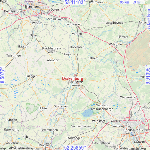
Drakenburg GPS coordinates[2]
52° 41' 12.804" North, 9° 12' 38.988" East
| Map corner | latitude | longitude |
|---|---|---|
| Upper-left | 53.11103°, | 8.5077° |
| Center: | 52.68689°, | 9.21083° |
| Lower-right: | 52.25859°, | 9.91395° |
| Map W x H: | 94.8×94.8 km | = 58.9×58.9mi |
| max Lat: | 55.01917° ⇑20.4% North |
| Drakenburg: | 52.68689° |
| min Lat: | ⇓79.6% South 47.40724° |
| min Long | Drakenburg | max Long |
| 5.92978° | 9.21083° | 14.98853° |
| W 37.8%⇐ | ⇒62.2% E |
Elevation
Elevation of Drakenburg is 26 m = 85 ft, and this is 223.1 m = 732 ft below average elevation for this country.
| Max E: |
1256 m = 4121 ft | 88.3% |
| Avg. | 249.1 m = 817 ft | |
| Drakenburg | 26 m = 85 ft | |
Min E: |
-5 m = -16 ft | 11.7% |
See also: Germany elevation on elevation.city.
Geographical zone
Drakenburg is located in North temperate zone (between Tropic of Cancer and the Arctic Circle). Distance of this North polar circle is 1542.9 km =958.7 mi to North.| Distance of | km | miles | from Drakenburg |
|---|---|---|---|
| North Pole | 4148.8 | 2577.9 | to North |
| Arctic Circle | 1542.9 | 958.7 | to North |
| Tropic Cancer | 3252.3 | 2020.9 | to South |
| Equator | 5858.2 | 3640.1 | to South |


Nearby cities:
15 places around Drakenburg: (largest is in red/bold)
• Balge
4.5 km =2.8 mi,  318°
318°
• Binnen
9.4 km =5.8 mi,  213°
213°
• Bücken
11.5 km =7.1 mi,  333°
333°
• Eystrup
10.3 km =6.4 mi,  0°
0°
• Gandesbergen
8.2 km =5.1 mi,  6°
6°
• Haßbergen
5.4 km =3.4 mi,  16°
16°
• Heemsen
4 km =2.5 mi,  68°
68°
• Hämelhausen
11.5 km =7.1 mi, 24°
• Marklohe
5.1 km =3.2 mi,  246°
246°
• Nienburg
4.6 km =2.9 mi,  171°
171°
• Röhrsen
3 km =1.9 mi,  27°
27°
• Schweringen
7.3 km =4.5 mi,  345°
345°
• Stöckse
10.1 km =6.3 mi,  120°
120°
• Warpe
9.1 km =5.7 mi,  304°
304°
• Wietzen
9.2 km =5.7 mi,  291°
291°
Sources, notices
• [Note1] Compared only with cities in Germany existing in our database
• [Src1] Map data: © OpenStreetMap contributors (CC-BY-SA)
• [Src2] Other city data from geonames.org with taken over terms of usage.
• [Src3] Geographical zone / Annual Mean Temperature by Robert A. Rohde @ Wikipedia
