Binnen geodata
Binnen (Lower Saxony) is a seat of a fourth-order administrative division; located in Germany in Europe/Berlin (GMT+2) time zone. With population of 1,051 people, there are 6997 cities with bigger population in this country. Compared to other cities in Germany, 78.9% of cities are located further ↓South; 63.5% of cities are located further →East and 75.8% of cities have higher elevation than Binnen. Note1


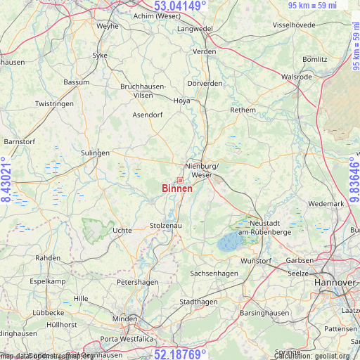
Binnen GPS coordinates[2]
52° 37' 0.012" North, 9° 7' 59.988" East
| Map corner | latitude | longitude |
|---|---|---|
| Upper-left | 53.04149°, | 8.43021° |
| Center: | 52.61667°, | 9.13333° |
| Lower-right: | 52.18769°, | 9.83646° |
| Map W x H: | 94.9×94.9 km | = 59×59mi |
| max Lat: | 55.01917° ⇑21.1% North |
| Binnen: | 52.61667° |
| min Lat: | ⇓78.9% South 47.40724° |
| min Long | Binnen | max Long |
| 5.92978° | 9.13333° | 14.98853° |
| W 36.5%⇐ | ⇒63.5% E |
Elevation
Elevation of Binnen is 60 m = 197 ft, and this is 189.1 m = 620 ft below average elevation for this country.
| Max E: |
1256 m = 4121 ft | 75.8% |
| Avg. | 249.1 m = 817 ft | |
| Binnen | 60 m = 197 ft | |
Min E: |
-5 m = -16 ft | 24.2% |
See also: Germany elevation on elevation.city.
Geographical zone
Binnen is located in North temperate zone (between Tropic of Cancer and the Arctic Circle). Distance of this North polar circle is 1550.7 km =963.6 mi to North.| Distance of | km | miles | from Binnen |
|---|---|---|---|
| North Pole | 4156.6 | 2582.8 | to North |
| Arctic Circle | 1550.7 | 963.6 | to North |
| Tropic Cancer | 3244.5 | 2016 | to South |
| Equator | 5850.4 | 3635.3 | to South |


Nearby cities:
15 places around Binnen: (largest is in red/bold)
• Balge
11.3 km =7 mi,  11°
11°
• Borstel
12.6 km =7.8 mi,  298°
298°
• Drakenburg
9.4 km =5.8 mi,  33°
33°
• Estorf
3.2 km =2 mi,  170°
170°
• Husum
9.6 km =6 mi,  125°
125°
• Landesbergen
6.8 km =4.2 mi,  184°
184°
• Liebenau
2.8 km =1.7 mi,  239°
239°
• Linsburg
11.7 km =7.3 mi,  102°
102°
• Marklohe
5.8 km =3.6 mi, 5°
• Nienburg
6.8 km =4.2 mi,  61°
61°
• Pennigsehl
7.7 km =4.8 mi,  291°
291°
• Röhrsen
12.4 km =7.7 mi, 32°
• Steyerberg
9 km =5.6 mi,  234°
234°
• Stolzenau
12 km =7.5 mi,  202°
202°
• Wietzen
11.6 km =7.2 mi,  343°
343°
Sources, notices
• [Note1] Compared only with cities in Germany existing in our database
• [Src1] Map data: © OpenStreetMap contributors (CC-BY-SA)
• [Src2] Other city data from geonames.org with taken over terms of usage.
• [Src3] Geographical zone / Annual Mean Temperature by Robert A. Rohde @ Wikipedia
