Heemsen geodata
Heemsen (Lower Saxony) is a seat of a fourth-order administrative division; located in Germany in Europe/Berlin (GMT+2) time zone. With population of 1,686 people, there are 5537 cities with bigger population in this country. Compared to other cities in Germany, 79.7% of cities are located further ↓South; 61.3% of cities are located further →East and 88.9% of cities have higher elevation than Heemsen. Note1
Administrative division(s):
- Level 1: Lower Saxony
- Level 3: Landkreis Nienburg/Weser
- Level 4: Heemsen


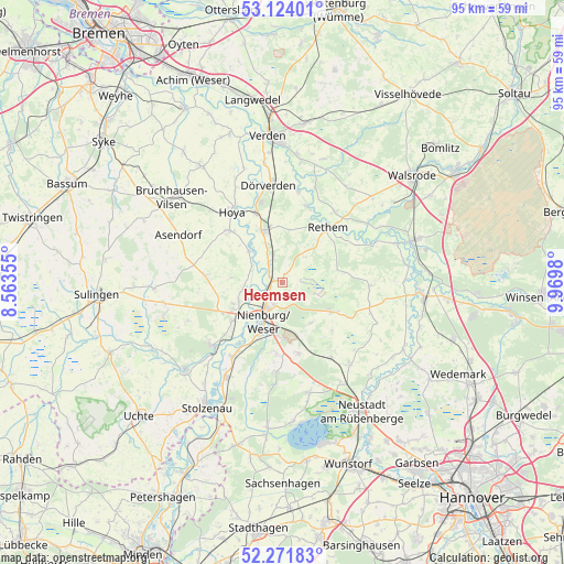
Heemsen GPS coordinates[2]
52° 42' 0" North, 9° 16' 0.012" East
| Map corner | latitude | longitude |
|---|---|---|
| Upper-left | 53.12401°, | 8.56355° |
| Center: | 52.7°, | 9.26667° |
| Lower-right: | 52.27183°, | 9.9698° |
| Map W x H: | 94.8×94.8 km | = 58.9×58.9mi |
| max Lat: | 55.01917° ⇑20.3% North |
| Heemsen: | 52.7° |
| min Lat: | ⇓79.7% South 47.40724° |
| min Long | Heemsen | max Long |
| 5.92978° | 9.26667° | 14.98853° |
| W 38.7%⇐ | ⇒61.3% E |
Elevation
Elevation of Heemsen is 24 m = 79 ft, and this is 225.1 m = 739 ft below average elevation for this country.
| Max E: |
1256 m = 4121 ft | 88.9% |
| Avg. | 249.1 m = 817 ft | |
| Heemsen | 24 m = 79 ft | |
Min E: |
-5 m = -16 ft | 11.1% |
See also: Germany elevation on elevation.city.
Geographical zone
Heemsen is located in North temperate zone (between Tropic of Cancer and the Arctic Circle). Distance of this North polar circle is 1541.5 km =957.8 mi to North.| Distance of | km | miles | from Heemsen |
|---|---|---|---|
| North Pole | 4147.4 | 2577.1 | to North |
| Arctic Circle | 1541.5 | 957.8 | to North |
| Tropic Cancer | 3253.8 | 2021.8 | to South |
| Equator | 5859.7 | 3641 | to South |


Nearby cities:
15 places around Heemsen: (largest is in red/bold)
• Balge
7 km =4.3 mi,  285°
285°
• Drakenburg
4 km =2.5 mi,  248°
248°
• Eystrup
9.5 km =5.9 mi,  337°
337°
• Gandesbergen
7.2 km =4.5 mi, 337°
• Haßbergen
4.3 km =2.7 mi,  328°
328°
• Hämelhausen
9.1 km =5.7 mi,  6°
6°
• Linsburg
12.1 km =7.5 mi,  168°
168°
• Marklohe
9.1 km =5.7 mi, 247°
• Nienburg
6.7 km =4.2 mi,  207°
207°
• Rethem
12.2 km =7.6 mi,  38°
38°
• Röhrsen
2.7 km =1.7 mi,  296°
296°
• Schweringen
7.9 km =4.9 mi,  314°
314°
• Steimbke
9.8 km =6.1 mi,  120°
120°
• Stöckse
8.3 km =5.2 mi,  143°
143°
• Warpe
11.8 km =7.3 mi, 288°
Sources, notices
• [Note1] Compared only with cities in Germany existing in our database
• [Src1] Map data: © OpenStreetMap contributors (CC-BY-SA)
• [Src2] Other city data from geonames.org with taken over terms of usage.
• [Src3] Geographical zone / Annual Mean Temperature by Robert A. Rohde @ Wikipedia
