Stöckse geodata
Stöckse (Lower Saxony) is a seat of a fourth-order administrative division; located in Germany in Europe/Berlin (GMT+2) time zone. With population of 1,400 people, there are 6077 cities with bigger population in this country. Compared to other cities in Germany, 79.2% of cities are located further ↓South; 60.2% of cities are located further →East and 80.6% of cities have higher elevation than Stöckse. Note1
Administrative division(s):
- Level 1: Lower Saxony
- Level 3: Landkreis Nienburg/Weser
- Level 4: Stöckse


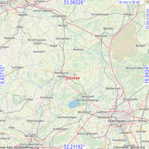
Stöckse GPS coordinates[2]
52° 38' 26.412" North, 9° 20' 24.972" East
| Map corner | latitude | longitude |
|---|---|---|
| Upper-left | 53.06526°, | 8.63715° |
| Center: | 52.64067°, | 9.34027° |
| Lower-right: | 52.21192°, | 10.0434° |
| Map W x H: | 94.9×94.9 km | = 59×59mi |
| max Lat: | 55.01917° ⇑20.8% North |
| Stöckse: | 52.64067° |
| min Lat: | ⇓79.2% South 47.40724° |
| min Long | Stöckse | max Long |
| 5.92978° | 9.34027° | 14.98853° |
| W 39.8%⇐ | ⇒60.2% E |
Elevation
Elevation of Stöckse is 45 m = 148 ft, and this is 204.1 m = 670 ft below average elevation for this country.
| Max E: |
1256 m = 4121 ft | 80.6% |
| Avg. | 249.1 m = 817 ft | |
| Stöckse | 45 m = 148 ft | |
Min E: |
-5 m = -16 ft | 19.4% |
See also: Germany elevation on elevation.city.
Geographical zone
Stöckse is located in North temperate zone (between Tropic of Cancer and the Arctic Circle). Distance of this North polar circle is 1548.1 km =961.9 mi to North.| Distance of | km | miles | from Stöckse |
|---|---|---|---|
| North Pole | 4154 | 2581.2 | to North |
| Arctic Circle | 1548.1 | 961.9 | to North |
| Tropic Cancer | 3247.2 | 2017.7 | to South |
| Equator | 5853.1 | 3636.9 | to South |


Nearby cities:
15 places around Stöckse: (largest is in red/bold)
• Balge
14.4 km =8.9 mi,  305°
305°
• Binnen
14.2 km =8.8 mi,  259°
259°
• Drakenburg
10.1 km =6.3 mi,  300°
300°
• Estorf
14.6 km =9.1 mi,  246°
246°
• Frankenfeld
15.4 km =9.6 mi,  23°
23°
• Gandesbergen
15.4 km =9.6 mi,  329°
329°
• Haßbergen
12.6 km =7.8 mi, 325°
• Heemsen
8.3 km =5.2 mi,  323°
323°
• Husum
10.2 km =6.3 mi,  216°
216°
• Linsburg
5.8 km =3.6 mi,  205°
205°
• Marklohe
13.7 km =8.5 mi,  283°
283°
• Nienburg
8.1 km =5 mi,  274°
274°
• Röhrsen
10.7 km =6.6 mi, 316°
• Schweringen
16.1 km =10 mi, 318°
• Steimbke
3.8 km =2.4 mi,  65°
65°
Sources, notices
• [Note1] Compared only with cities in Germany existing in our database
• [Src1] Map data: © OpenStreetMap contributors (CC-BY-SA)
• [Src2] Other city data from geonames.org with taken over terms of usage.
• [Src3] Geographical zone / Annual Mean Temperature by Robert A. Rohde @ Wikipedia
