Weißenburg in Bayern geodata
Weißenburg in Bayern (Bavaria) is a populated place; located in Germany in Europe/Berlin (GMT+2) time zone. With population of 17,801 people, there are 893 cities with bigger population in this country. Compared to other cities in Germany, 82.7% of cities are located further ↑North; 66.6% of cities are located further ←West and 79.1% of cities have lower elevation than Weißenburg in Bayern. Note1
Administrative division(s):
- Level 1: Bavaria
- Level 2: Regierungsbezirk Mittelfranken
- Level 3: Landkreis Weißenburg-Gunzenhausen
- Level 4: Weißenburg i.Bay.


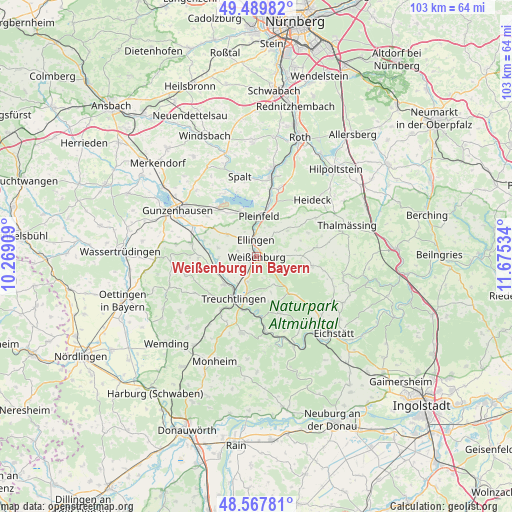
Weißenburg in Bayern GPS coordinates[2]
49° 1' 51.42" North, 10° 58' 19.956" East
| Map corner | latitude | longitude |
|---|---|---|
| Upper-left | 49.48982°, | 10.26909° |
| Center: | 49.03095°, | 10.97221° |
| Lower-right: | 48.56781°, | 11.67534° |
| Map W x H: | 102.5×102.5 km | = 63.7×63.7mi |
| max Lat: | 55.01917° ⇑82.7% North |
| Weißenburg in Bayern: | 49.03095° |
| min Lat: | ⇓17.3% South 47.40724° |
| min Long | Weißenburg in | max Long |
| 5.92978° | 10.97221° | 14.98853° |
| W 66.6%⇐ | ⇒33.4% E |
Elevation
Elevation of Weißenburg in Bayern is 428 m = 1404 ft, and this is 178.9 m = 587 ft above average elevation for this country.
| Max E: |
1256 m = 4121 ft | 20.9% |
| Weißenburg in Bayern | 428 m 1404 ft | |
| Avg. | 249.1 m = 817 ft | |
Min E: |
-5 m = -16 ft | 79.1% |
See also: Germany elevation on elevation.city.
Geographical zone
Weißenburg in Bayern is located in North temperate zone (between Tropic of Cancer and the Arctic Circle). Distance of this North polar circle is 1949.4 km =1211.3 mi to North.| Distance of | km | miles | from Weißenburg in Bayern |
|---|---|---|---|
| North Pole | 4555.3 | 2830.5 | to North |
| Arctic Circle | 1949.4 | 1211.3 | to North |
| Tropic Cancer | 2845.8 | 1768.3 | to South |
| Equator | 5451.7 | 3387.5 | to South |


Nearby cities:
15 places around Weißenburg in Bayern: (largest is in red/bold)
• Alesheim
8 km =5 mi,  282°
282°
• Bergen
11.4 km =7.1 mi,  65°
65°
• Burgsalach
9.1 km =5.7 mi,  88°
88°
• Dittenheim
13.4 km =8.3 mi, 281°
• Ellingen
3.3 km =2.1 mi,  354°
354°
• Ettenstatt
8 km =5 mi,  49°
49°
• Höttingen
4.3 km =2.7 mi,  34°
34°
• Markt Berolzheim
9.6 km =6 mi,  255°
255°
• Meinheim
11.3 km =7 mi,  271°
271°
• Nennslingen
11.7 km =7.3 mi,  81°
81°
• Pappenheim
10.8 km =6.7 mi,  179°
179°
• Pfofeld
12.9 km =8 mi,  310°
310°
• Pleinfeld
8.2 km =5.1 mi,  4°
4°
• Raitenbuch
11.3 km =7 mi,  99°
99°
• Treuchtlingen
9.7 km =6 mi,  208°
208°
Sources, notices
• [Note1] Compared only with cities in Germany existing in our database
• [Src1] Map data: © OpenStreetMap contributors (CC-BY-SA)
• [Src2] Other city data from geonames.org with taken over terms of usage.
• [Src3] Geographical zone / Annual Mean Temperature by Robert A. Rohde @ Wikipedia
