Schweighausen geodata
Schweighausen (Rheinland-Pfalz) is a seat of a fourth-order administrative division; located in Germany in Europe/Berlin (GMT+2) time zone. With population of 260 people, there are 10208 cities with bigger population in this country. Compared to other cities in Germany, 57.2% of cities are located further ↑North; 82.1% of cities are located further →East and 72.6% of cities have lower elevation than Schweighausen. Note1
Administrative division(s):
- Level 1: Rheinland-Pfalz
- Level 3: Rhein-Lahn-Kreis
- Level 4: Schweighausen


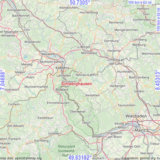
Schweighausen GPS coordinates[2]
50° 16' 59.988" North, 7° 45' 0" East
| Map corner | latitude | longitude |
|---|---|---|
| Upper-left | 50.7305°, | 7.04688° |
| Center: | 50.28333°, | 7.75° |
| Lower-right: | 49.83192°, | 8.45313° |
| Map W x H: | 99.9×99.9 km | = 62.1×62.1mi |
| max Lat: | 55.01917° ⇑57.2% North |
| Schweighausen: | 50.28333° |
| min Lat: | ⇓42.8% South 47.40724° |
| min Long | Schweighausen | max Long |
| 5.92978° | 7.75° | 14.98853° |
| W 17.9%⇐ | ⇒82.1% E |
Elevation
Elevation of Schweighausen is 379 m = 1243 ft, and this is 129.9 m = 426 ft above average elevation for this country.
| Max E: |
1256 m = 4121 ft | 27.4% |
| Schweighausen | 379 m 1243 ft | |
| Avg. | 249.1 m = 817 ft | |
Min E: |
-5 m = -16 ft | 72.6% |
See also: Germany elevation on elevation.city.
Geographical zone
Schweighausen is located in North temperate zone (between Tropic of Cancer and the Arctic Circle). Distance of this North polar circle is 1810.2 km =1124.8 mi to North.| Distance of | km | miles | from Schweighausen |
|---|---|---|---|
| North Pole | 4416.1 | 2744 | to North |
| Arctic Circle | 1810.2 | 1124.8 | to North |
| Tropic Cancer | 2985.1 | 1854.9 | to South |
| Equator | 5591 | 3474.1 | to South |


Nearby cities:
15 places around Schweighausen: (largest is in red/bold)
• Becheln
2.5 km =1.6 mi,  294°
294°
• Berg
5.4 km =3.4 mi,  126°
126°
• Dachsenhausen
3.6 km =2.2 mi,  206°
206°
• Dessighofen
3.2 km =2 mi,  150°
150°
• Dienethal
3 km =1.9 mi,  40°
40°
• Dornholzhausen
3.2 km =2 mi,  117°
117°
• Geisig
4.4 km =2.7 mi,  138°
138°
• Kehlbach
2.8 km =1.7 mi,  166°
166°
• Misselberg
3 km =1.9 mi,  27°
27°
• Nassau
5 km =3.1 mi,  45°
45°
• Niederbachheim
4.1 km =2.5 mi,  163°
163°
• Oberbachheim
4.1 km =2.5 mi,  182°
182°
• Oberwies
2.2 km =1.4 mi,  74°
74°
• Sulzbach
2.1 km =1.3 mi,  4°
4°
• Winterwerb
5.3 km =3.3 mi,  188°
188°
Sources, notices
• [Note1] Compared only with cities in Germany existing in our database
• [Src1] Map data: © OpenStreetMap contributors (CC-BY-SA)
• [Src2] Other city data from geonames.org with taken over terms of usage.
• [Src3] Geographical zone / Annual Mean Temperature by Robert A. Rohde @ Wikipedia
