Ersingen geodata
Ersingen (Baden-Württemberg) is a populated place; located in Germany in Europe/Berlin (GMT+2) time zone. With population of 1,200 people, there are 6562 cities with bigger population in this country. Compared to other cities in Germany, 91.3% of cities are located further ↑North; 52% of cities are located further →East and 86.8% of cities have lower elevation than Ersingen. Note1
Administrative division(s):
- Level 1: Baden-Württemberg
- Level 2: Tübingen Region
- Level 3: Alb-Donau-Kreis
- Level 4: Erbach


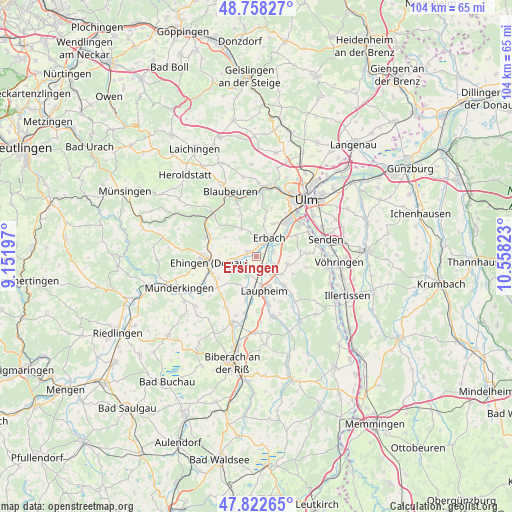
Ersingen GPS coordinates[2]
48° 17' 33.36" North, 9° 51' 18.36" East
| Map corner | latitude | longitude |
|---|---|---|
| Upper-left | 48.75827°, | 9.15197° |
| Center: | 48.2926°, | 9.8551° |
| Lower-right: | 47.82265°, | 10.55823° |
| Map W x H: | 104×104 km | = 64.6×64.6mi |
| max Lat: | 55.01917° ⇑91.3% North |
| Ersingen: | 48.2926° |
| min Lat: | ⇓8.7% South 47.40724° |
| min Long | Ersingen | max Long |
| 5.92978° | 9.8551° | 14.98853° |
| W 48%⇐ | ⇒52% E |
Elevation
Elevation of Ersingen is 484 m = 1588 ft, and this is 234.9 m = 771 ft above average elevation for this country.
| Max E: |
1256 m = 4121 ft | 13.2% |
| Ersingen | 484 m 1588 ft | |
| Avg. | 249.1 m = 817 ft | |
Min E: |
-5 m = -16 ft | 86.8% |
See also: Germany elevation on elevation.city.
Geographical zone
Ersingen is located in North temperate zone (between Tropic of Cancer and the Arctic Circle). Distance of this North polar circle is 2031.5 km =1262.3 mi to North.| Distance of | km | miles | from Ersingen |
|---|---|---|---|
| North Pole | 4637.4 | 2881.5 | to North |
| Arctic Circle | 2031.5 | 1262.3 | to North |
| Tropic Cancer | 2763.7 | 1717.3 | to South |
| Equator | 5369.6 | 3336.5 | to South |


Nearby cities:
15 places around Ersingen: (largest is in red/bold)
• Achstetten
4.9 km =3 mi,  140°
140°
• Allmendingen
10.6 km =6.6 mi,  293°
293°
• Altheim
7.4 km =4.6 mi,  302°
302°
• Burgrieden
8.8 km =5.5 mi, 138°
• Dettingen
10.4 km =6.5 mi,  251°
251°
• Ehingen
9.5 km =5.9 mi,  263°
263°
• Erbach
4.6 km =2.9 mi,  31°
31°
• Griesingen
6 km =3.7 mi,  241°
241°
• Hüttisheim
6.6 km =4.1 mi,  102°
102°
• Laupheim
7.4 km =4.6 mi,  166°
166°
• Mietingen
12.6 km =7.8 mi,  164°
164°
• Oberdischingen
1.8 km =1.1 mi, 297°
• Schnürpflingen
10.4 km =6.5 mi, 102°
• Staig
10.1 km =6.3 mi,  85°
85°
• Öpfingen
3.9 km =2.4 mi, 259°
Sources, notices
• [Note1] Compared only with cities in Germany existing in our database
• [Src1] Map data: © OpenStreetMap contributors (CC-BY-SA)
• [Src2] Other city data from geonames.org with taken over terms of usage.
• [Src3] Geographical zone / Annual Mean Temperature by Robert A. Rohde @ Wikipedia
