Ockenfels geodata
Ockenfels (Rheinland-Pfalz) is a seat of a fourth-order administrative division; located in Germany in Europe/Berlin (GMT+2) time zone. With population of 1,101 people, there are 6845 cities with bigger population in this country. Compared to other cities in Germany, 51.2% of cities are located further ↑North; 90.4% of cities are located further →East and 64.5% of cities have higher elevation than Ockenfels. Note1


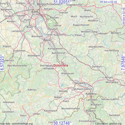
Ockenfels GPS coordinates[2]
50° 34' 33.96" North, 7° 16' 31.26" East
| Map corner | latitude | longitude |
|---|---|---|
| Upper-left | 51.02051°, | 6.57223° |
| Center: | 50.5761°, | 7.27535° |
| Lower-right: | 50.12746°, | 7.97848° |
| Map W x H: | 99.3×99.3 km | = 61.7×61.7mi |
| max Lat: | 55.01917° ⇑51.2% North |
| Ockenfels: | 50.5761° |
| min Lat: | ⇓48.8% South 47.40724° |
| min Long | Ockenfels | max Long |
| 5.92978° | 7.27535° | 14.98853° |
| W 9.6%⇐ | ⇒90.4% E |
Elevation
Elevation of Ockenfels is 124 m = 407 ft, and this is 125.1 m = 410 ft below average elevation for this country.
| Max E: |
1256 m = 4121 ft | 64.5% |
| Avg. | 249.1 m = 817 ft | |
| Ockenfels | 124 m = 407 ft | |
Min E: |
-5 m = -16 ft | 35.5% |
See also: Germany elevation on elevation.city.
Geographical zone
Ockenfels is located in North temperate zone (between Tropic of Cancer and the Arctic Circle). Distance of this North polar circle is 1777.6 km =1104.5 mi to North.| Distance of | km | miles | from Ockenfels |
|---|---|---|---|
| North Pole | 4383.5 | 2723.8 | to North |
| Arctic Circle | 1777.6 | 1104.5 | to North |
| Tropic Cancer | 3017.6 | 1875 | to South |
| Equator | 5623.5 | 3494.3 | to South |


Nearby cities:
15 places around Ockenfels: (largest is in red/bold)
• Bad Breisig
7.9 km =4.9 mi,  173°
173°
• Bad Hönningen
7.1 km =4.4 mi,  158°
158°
• Bruchhausen
3.2 km =2 mi,  326°
326°
• Dattenberg
2.8 km =1.7 mi,  152°
152°
• Erpel
3.1 km =1.9 mi,  285°
285°
• Kalenborn
5.2 km =3.2 mi,  32°
32°
• Kasbach-Ohlenberg
1 km =0.6 mi,  322°
322°
• Leubsdorf
3.4 km =2.1 mi, 149°
• Linz am Rhein
1 km =0.6 mi,  141°
141°
• Remagen
3.4 km =2.1 mi,  275°
275°
• Rheinbreitbach
5.4 km =3.4 mi, 326°
• Sankt Katharinen
7.7 km =4.8 mi,  83°
83°
• Sinzig
4.1 km =2.5 mi,  209°
209°
• Unkel
4.6 km =2.9 mi,  299°
299°
• Vettelschoß
6.9 km =4.3 mi,  49°
49°
Sources, notices
• [Note1] Compared only with cities in Germany existing in our database
• [Src1] Map data: © OpenStreetMap contributors (CC-BY-SA)
• [Src2] Other city data from geonames.org with taken over terms of usage.
• [Src3] Geographical zone / Annual Mean Temperature by Robert A. Rohde @ Wikipedia
