Bruchhausen geodata
Bruchhausen (Rheinland-Pfalz) is a seat of a fourth-order administrative division; located in Germany in Europe/Berlin (GMT+2) time zone. With population of 929 people, there are 7423 cities with bigger population in this country. Compared to other cities in Germany, 50.6% of cities are located further ↑North; 90.8% of cities are located further →East and 54.9% of cities have higher elevation than Bruchhausen. Note1
Administrative division(s):
- Level 1: Rheinland-Pfalz
- Level 3: Landkreis Neuwied
- Level 4: Bruchhausen


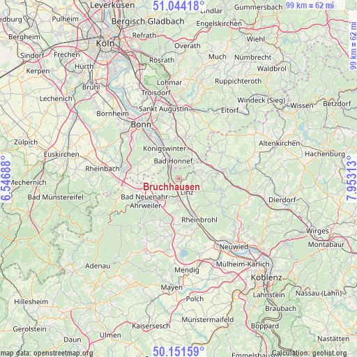
Bruchhausen GPS coordinates[2]
50° 36' 0" North, 7° 15' 0" East
| Map corner | latitude | longitude |
|---|---|---|
| Upper-left | 51.04418°, | 6.54688° |
| Center: | 50.6°, | 7.25° |
| Lower-right: | 50.15159°, | 7.95313° |
| Map W x H: | 99.2×99.2 km | = 61.6×61.6mi |
| max Lat: | 55.01917° ⇑50.6% North |
| Bruchhausen: | 50.6° |
| min Lat: | ⇓49.4% South 47.40724° |
| min Long | Bruchhausen | max Long |
| 5.92978° | 7.25° | 14.98853° |
| W 9.2%⇐ | ⇒90.8% E |
Elevation
Elevation of Bruchhausen is 190 m = 623 ft, and this is 59.1 m = 194 ft below average elevation for this country.
| Max E: |
1256 m = 4121 ft | 54.9% |
| Avg. | 249.1 m = 817 ft | |
| Bruchhausen | 190 m = 623 ft | |
Min E: |
-5 m = -16 ft | 45.1% |
See also: Germany elevation on elevation.city.
Geographical zone
Bruchhausen is located in North temperate zone (between Tropic of Cancer and the Arctic Circle). Distance of this North polar circle is 1775 km =1102.9 mi to North.| Distance of | km | miles | from Bruchhausen |
|---|---|---|---|
| North Pole | 4380.9 | 2722.2 | to North |
| Arctic Circle | 1775 | 1102.9 | to North |
| Tropic Cancer | 3020.3 | 1876.7 | to South |
| Equator | 5626.2 | 3496 | to South |


Nearby cities:
15 places around Bruchhausen: (largest is in red/bold)
• Bad Honnef
5.1 km =3.2 mi,  342°
342°
• Dattenberg
6 km =3.7 mi,  148°
148°
• Erpel
2.2 km =1.4 mi,  212°
212°
• Kalenborn
4.9 km =3 mi,  69°
69°
• Kasbach-Ohlenberg
2.2 km =1.4 mi, 147°
• Leubsdorf
6.6 km =4.1 mi, 147°
• Linz am Rhein
4.2 km =2.6 mi,  144°
144°
• Ockenfels
3.2 km =2 mi, 146°
• Remagen
2.9 km =1.8 mi, 214°
• Rheinbreitbach
2.2 km =1.4 mi,  327°
327°
• Sankt Katharinen
9.6 km =6 mi,  101°
101°
• Sinzig
6.2 km =3.9 mi,  182°
182°
• Unkel
2.2 km =1.4 mi,  260°
260°
• Vettelschoß
7.3 km =4.5 mi,  75°
75°
• Windhagen
8.6 km =5.3 mi,  57°
57°
Sources, notices
• [Note1] Compared only with cities in Germany existing in our database
• [Src1] Map data: © OpenStreetMap contributors (CC-BY-SA)
• [Src2] Other city data from geonames.org with taken over terms of usage.
• [Src3] Geographical zone / Annual Mean Temperature by Robert A. Rohde @ Wikipedia
