Wentorf bei Hamburg geodata
Wentorf bei Hamburg (Schleswig-Holstein) is a seat of a fourth-order administrative division; located in Germany in Europe/Berlin (GMT+2) time zone. With population of 12,104 people, there are 1357 cities with bigger population in this country. Compared to other cities in Germany, 85.5% of cities are located further ↓South; 54.3% of cities are located further ←West and 83.7% of cities have higher elevation than Wentorf bei Hamburg. Note1
Administrative division(s):
- Level 1: Schleswig-Holstein
- Level 3: Kreis Herzogtum Lauenburg
- Level 4: Wentorf bei Hamburg


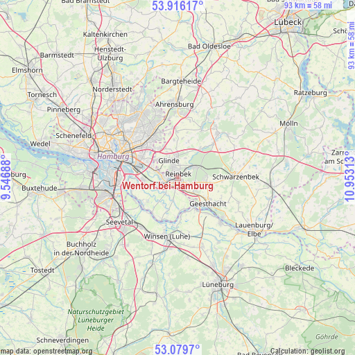
Wentorf bei Hamburg GPS coordinates[2]
53° 30' 0" North, 10° 15' 0" East
| Map corner | latitude | longitude |
|---|---|---|
| Upper-left | 53.91617°, | 9.54688° |
| Center: | 53.5°, | 10.25° |
| Lower-right: | 53.0797°, | 10.95313° |
| Map W x H: | 93×93 km | = 57.8×57.8mi |
| max Lat: | 55.01917° ⇑14.5% North |
| Wentorf bei Hamburg: | 53.5° |
| min Lat: | ⇓85.5% South 47.40724° |
| min Long | Wentorf bei Ham | max Long |
| 5.92978° | 10.25° | 14.98853° |
| W 54.3%⇐ | ⇒45.7% E |
Elevation
Elevation of Wentorf bei Hamburg is 38 m = 125 ft, and this is 211.1 m = 693 ft below average elevation for this country.
| Max E: |
1256 m = 4121 ft | 83.7% |
| Avg. | 249.1 m = 817 ft | |
| Wentorf bei Hamburg | 38 m = 125 ft | |
Min E: |
-5 m = -16 ft | 16.3% |
See also: Germany elevation on elevation.city.
Geographical zone
Wentorf bei Hamburg is located in North temperate zone (between Tropic of Cancer and the Arctic Circle). Distance of this North polar circle is 1452.5 km =902.5 mi to North.| Distance of | km | miles | from Wentorf bei Hamburg |
|---|---|---|---|
| North Pole | 4058.4 | 2521.8 | to North |
| Arctic Circle | 1452.5 | 902.5 | to North |
| Tropic Cancer | 3342.7 | 2077.1 | to South |
| Equator | 5948.6 | 3696.3 | to South |


Nearby cities:
15 places around Wentorf bei Hamburg: (largest is in red/bold)
• Barsbüttel
9.2 km =5.7 mi,  323°
323°
• Bergedorf
2.2 km =1.4 mi,  219°
219°
• Börnsen
3.4 km =2.1 mi,  141°
141°
• Dassendorf
7.3 km =4.5 mi,  94°
94°
• Drage
9.3 km =5.8 mi,  173°
173°
• Escheburg
5.8 km =3.6 mi,  130°
130°
• Geesthacht
11.1 km =6.9 mi, 130°
• Glinde
5.9 km =3.7 mi,  326°
326°
• Hohenhorn
8 km =5 mi,  109°
109°
• Kröppelshagen-Fahrendorf
4.6 km =2.9 mi,  104°
104°
• Oststeinbek
7.2 km =4.5 mi,  312°
312°
• Rausdorf
11.3 km =7 mi,  28°
28°
• Reinbek
1.9 km =1.2 mi,  357°
357°
• Witzhave
9.2 km =5.7 mi,  36°
36°
• Wohltorf
2.9 km =1.8 mi,  49°
49°
In other languages:
- In France: Wentorf près de Hambourg
- In Russian: Венторф-Хамбург
- In Chinese: 文托尔夫拜汉堡
Sources, notices
• [Note1] Compared only with cities in Germany existing in our database
• [Src1] Map data: © OpenStreetMap contributors (CC-BY-SA)
• [Src2] Other city data from geonames.org with taken over terms of usage.
• [Src3] Geographical zone / Annual Mean Temperature by Robert A. Rohde @ Wikipedia
