Dabergotz geodata
Dabergotz (Brandenburg) is a seat of a fourth-order administrative division; located in Germany in Europe/Berlin (GMT+2) time zone. With population of 594 people, there are 8858 cities with bigger population in this country. Compared to other cities in Germany, 81.1% of cities are located further ↓South; 90% of cities are located further ←West and 82.3% of cities have higher elevation than Dabergotz. Note1
Administrative division(s):
- Level 1: Brandenburg
- Level 3: Landkreis Ostprignitz-Ruppin
- Level 4: Dabergotz


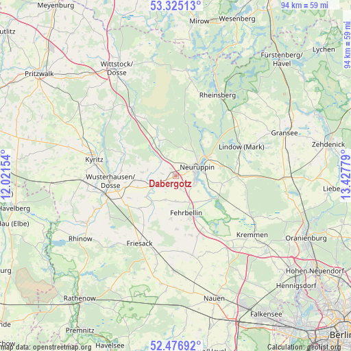
Dabergotz GPS coordinates[2]
52° 54' 11.16" North, 12° 43' 28.776" East
| Map corner | latitude | longitude |
|---|---|---|
| Upper-left | 53.32513°, | 12.02154° |
| Center: | 52.9031°, | 12.72466° |
| Lower-right: | 52.47692°, | 13.42779° |
| Map W x H: | 94.3×94.3 km | = 58.6×58.6mi |
| max Lat: | 55.01917° ⇑18.9% North |
| Dabergotz: | 52.9031° |
| min Lat: | ⇓81.1% South 47.40724° |
| min Long | Dabergotz | max Long |
| 5.92978° | 12.72466° | 14.98853° |
| W 90%⇐ | ⇒10% E |
Elevation
Elevation of Dabergotz is 41 m = 135 ft, and this is 208.1 m = 683 ft below average elevation for this country.
| Max E: |
1256 m = 4121 ft | 82.3% |
| Avg. | 249.1 m = 817 ft | |
| Dabergotz | 41 m = 135 ft | |
Min E: |
-5 m = -16 ft | 17.7% |
See also: Germany elevation on elevation.city.
Geographical zone
Dabergotz is located in North temperate zone (between Tropic of Cancer and the Arctic Circle). Distance of this North polar circle is 1518.9 km =943.8 mi to North.| Distance of | km | miles | from Dabergotz |
|---|---|---|---|
| North Pole | 4124.8 | 2563 | to North |
| Arctic Circle | 1518.9 | 943.8 | to North |
| Tropic Cancer | 3276.4 | 2035.9 | to South |
| Equator | 5882.3 | 3655.1 | to South |


Nearby cities:
15 places around Dabergotz: (largest is in red/bold)
• Dreetz
21 km =13 mi,  237°
237°
• Fehrbellin
10.3 km =6.4 mi,  165°
165°
• Friesack
20.8 km =12.9 mi,  207°
207°
• Großderschau
27 km =16.8 mi, 242°
• Herzberg
16.4 km =10.2 mi,  90°
90°
• Jahnberge
20.2 km =12.6 mi,  182°
182°
• Kremmen
25.6 km =15.9 mi,  127°
127°
• Kyritz
22.4 km =13.9 mi,  281°
281°
• Lindow
18.8 km =11.7 mi,  67°
67°
• Neuruppin
6 km =3.7 mi,  62°
62°
• Paulinenaue
25.2 km =15.7 mi, 182°
• Rheinsberg
24.8 km =15.4 mi,  28°
28°
• Rüthnick
18.4 km =11.4 mi,  97°
97°
• Walsleben
5.6 km =3.5 mi,  314°
314°
• Wusterhausen
17.8 km =11.1 mi,  265°
265°
Sources, notices
• [Note1] Compared only with cities in Germany existing in our database
• [Src1] Map data: © OpenStreetMap contributors (CC-BY-SA)
• [Src2] Other city data from geonames.org with taken over terms of usage.
• [Src3] Geographical zone / Annual Mean Temperature by Robert A. Rohde @ Wikipedia
