Paulinenaue geodata
Paulinenaue (Brandenburg) is a seat of a fourth-order administrative division; located in Germany in Europe/Berlin (GMT+2) time zone. With population of 1,327 people, there are 6228 cities with bigger population in this country. Compared to other cities in Germany, 79.5% of cities are located further ↓South; 89.9% of cities are located further ←West and 87.3% of cities have higher elevation than Paulinenaue. Note1


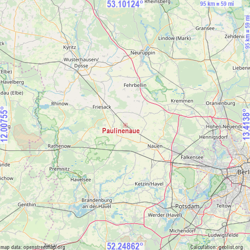
Paulinenaue GPS coordinates[2]
52° 40' 37.236" North, 12° 42' 38.412" East
| Map corner | latitude | longitude |
|---|---|---|
| Upper-left | 53.10124°, | 12.00755° |
| Center: | 52.67701°, | 12.71067° |
| Lower-right: | 52.24862°, | 13.4138° |
| Map W x H: | 94.8×94.8 km | = 58.9×58.9mi |
| max Lat: | 55.01917° ⇑20.5% North |
| Paulinenaue: | 52.67701° |
| min Lat: | ⇓79.5% South 47.40724° |
| min Long | Paulinenaue | max Long |
| 5.92978° | 12.71067° | 14.98853° |
| W 89.9%⇐ | ⇒10.1% E |
Elevation
Elevation of Paulinenaue is 29 m = 95 ft, and this is 220.1 m = 722 ft below average elevation for this country.
| Max E: |
1256 m = 4121 ft | 87.3% |
| Avg. | 249.1 m = 817 ft | |
| Paulinenaue | 29 m = 95 ft | |
Min E: |
-5 m = -16 ft | 12.7% |
See also: Germany elevation on elevation.city.
Geographical zone
Paulinenaue is located in North temperate zone (between Tropic of Cancer and the Arctic Circle). Distance of this North polar circle is 1544 km =959.4 mi to North.| Distance of | km | miles | from Paulinenaue |
|---|---|---|---|
| North Pole | 4149.9 | 2578.6 | to North |
| Arctic Circle | 1544 | 959.4 | to North |
| Tropic Cancer | 3251.2 | 2020.2 | to South |
| Equator | 5857.1 | 3639.4 | to South |


Nearby cities:
15 places around Paulinenaue: (largest is in red/bold)
• Brieselang
22.1 km =13.7 mi,  118°
118°
• Dreetz
21.9 km =13.6 mi,  309°
309°
• Fehrbellin
15.6 km =9.7 mi,  13°
13°
• Friesack
11.1 km =6.9 mi, 307°
• Jahnberge
5 km =3.1 mi,  0°
0°
• Ketzin
23.9 km =14.9 mi,  157°
157°
• Kotzen
14 km =8.7 mi,  249°
249°
• Kremmen
23.2 km =14.4 mi,  65°
65°
• Nauen
13.5 km =8.4 mi,  125°
125°
• Nennhausen
16.6 km =10.3 mi,  238°
238°
• Pessin
4.9 km =3 mi,  217°
217°
• Päwesin
17.8 km =11.1 mi,  178°
178°
• Retzow
6.1 km =3.8 mi,  196°
196°
• Roskow
22.8 km =14.2 mi, 178°
• Wustermark
21.5 km =13.4 mi, 131°
Sources, notices
• [Note1] Compared only with cities in Germany existing in our database
• [Src1] Map data: © OpenStreetMap contributors (CC-BY-SA)
• [Src2] Other city data from geonames.org with taken over terms of usage.
• [Src3] Geographical zone / Annual Mean Temperature by Robert A. Rohde @ Wikipedia
