Fehrbellin geodata
Fehrbellin (Brandenburg) is a seat of a fourth-order administrative division; located in Germany in Europe/Berlin (GMT+2) time zone. With population of 9,413 people, there are 1718 cities with bigger population in this country. Compared to other cities in Germany, 80.5% of cities are located further ↓South; 90.4% of cities are located further ←West and 83.2% of cities have higher elevation than Fehrbellin. Note1
Administrative division(s):
- Level 1: Brandenburg
- Level 3: Landkreis Ostprignitz-Ruppin
- Level 4: Fehrbellin


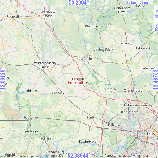
Fehrbellin GPS coordinates[2]
52° 48' 48.6" North, 12° 45' 51.84" East
| Map corner | latitude | longitude |
|---|---|---|
| Upper-left | 53.2364°, | 12.06128° |
| Center: | 52.8135°, | 12.7644° |
| Lower-right: | 52.38644°, | 13.46753° |
| Map W x H: | 94.5×94.5 km | = 58.7×58.7mi |
| max Lat: | 55.01917° ⇑19.5% North |
| Fehrbellin: | 52.8135° |
| min Lat: | ⇓80.5% South 47.40724° |
| min Long | Fehrbellin | max Long |
| 5.92978° | 12.7644° | 14.98853° |
| W 90.4%⇐ | ⇒9.6% E |
Elevation
Elevation of Fehrbellin is 39 m = 128 ft, and this is 210.1 m = 689 ft below average elevation for this country.
| Max E: |
1256 m = 4121 ft | 83.2% |
| Avg. | 249.1 m = 817 ft | |
| Fehrbellin | 39 m = 128 ft | |
Min E: |
-5 m = -16 ft | 16.8% |
See also: Germany elevation on elevation.city.
Geographical zone
Fehrbellin is located in North temperate zone (between Tropic of Cancer and the Arctic Circle). Distance of this North polar circle is 1528.9 km =950 mi to North.| Distance of | km | miles | from Fehrbellin |
|---|---|---|---|
| North Pole | 4134.8 | 2569.2 | to North |
| Arctic Circle | 1528.9 | 950 | to North |
| Tropic Cancer | 3266.4 | 2029.6 | to South |
| Equator | 5872.3 | 3648.9 | to South |


Nearby cities:
15 places around Fehrbellin: (largest is in red/bold)
• Dabergotz
10.3 km =6.4 mi,  345°
345°
• Dreetz
20.5 km =12.7 mi,  266°
266°
• Friesack
15 km =9.3 mi,  235°
235°
• Herzberg
17 km =10.6 mi,  54°
54°
• Jahnberge
10.8 km =6.7 mi,  199°
199°
• Kremmen
18.4 km =11.4 mi,  108°
108°
• Lindow
22.6 km =14 mi,  40°
40°
• Nauen
24.1 km =15 mi,  162°
162°
• Neuruppin
13 km =8.1 mi,  11°
11°
• Paulinenaue
15.6 km =9.7 mi,  193°
193°
• Pessin
20.1 km =12.5 mi, 199°
• Retzow
21.6 km =13.4 mi, 194°
• Rüthnick
17.3 km =10.7 mi,  64°
64°
• Walsleben
15.4 km =9.6 mi,  334°
334°
• Wusterhausen
22.2 km =13.8 mi,  292°
292°
Sources, notices
• [Note1] Compared only with cities in Germany existing in our database
• [Src1] Map data: © OpenStreetMap contributors (CC-BY-SA)
• [Src2] Other city data from geonames.org with taken over terms of usage.
• [Src3] Geographical zone / Annual Mean Temperature by Robert A. Rohde @ Wikipedia
