Lindow geodata
Lindow (Brandenburg) is a populated place; located in Germany in Europe/Berlin (GMT+2) time zone. With population of 3,336 people, there are 3731 cities with bigger population in this country. Compared to other cities in Germany, 81.6% of cities are located further ↓South; 92.2% of cities are located further ←West and 82.3% of cities have higher elevation than Lindow. Note1
Administrative division(s):
- Level 1: Brandenburg
- Level 3: Landkreis Ostprignitz-Ruppin
- Level 4: Lindow (Mark)


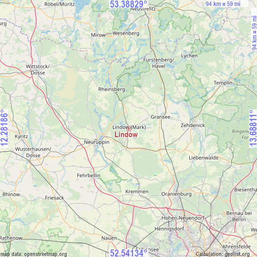
Lindow GPS coordinates[2]
52° 58' 0.804" North, 12° 59' 5.928" East
| Map corner | latitude | longitude |
|---|---|---|
| Upper-left | 53.38829°, | 12.28186° |
| Center: | 52.96689°, | 12.98498° |
| Lower-right: | 52.54134°, | 13.68811° |
| Map W x H: | 94.2×94.2 km | = 58.5×58.5mi |
| max Lat: | 55.01917° ⇑18.4% North |
| Lindow: | 52.96689° |
| min Lat: | ⇓81.6% South 47.40724° |
| min Long | Lindow | max Long |
| 5.92978° | 12.98498° | 14.98853° |
| W 92.2%⇐ | ⇒7.8% E |
Elevation
Elevation of Lindow is 41 m = 135 ft, and this is 208.1 m = 683 ft below average elevation for this country.
| Max E: |
1256 m = 4121 ft | 82.3% |
| Avg. | 249.1 m = 817 ft | |
| Lindow | 41 m = 135 ft | |
Min E: |
-5 m = -16 ft | 17.7% |
See also: Germany elevation on elevation.city.
Geographical zone
Lindow is located in North temperate zone (between Tropic of Cancer and the Arctic Circle). Distance of this North polar circle is 1511.8 km =939.4 mi to North.| Distance of | km | miles | from Lindow |
|---|---|---|---|
| North Pole | 4117.7 | 2558.6 | to North |
| Arctic Circle | 1511.8 | 939.4 | to North |
| Tropic Cancer | 3283.4 | 2040.2 | to South |
| Equator | 5889.4 | 3659.5 | to South |


Nearby cities:
15 places around Lindow: (largest is in red/bold)
• Dabergotz
18.8 km =11.7 mi,  247°
247°
• Fehrbellin
22.6 km =14 mi,  220°
220°
• Fürstenberg
26.4 km =16.4 mi,  23°
23°
• Gransee
12.4 km =7.7 mi,  68°
68°
• Großwoltersdorf
13.5 km =8.4 mi,  34°
34°
• Herzberg
7.2 km =4.5 mi,  188°
188°
• Kremmen
22.9 km =14.2 mi,  173°
173°
• Neuruppin
12.9 km =8 mi, 250°
• Oranienburg
29.1 km =18.1 mi,  143°
143°
• Rheinsberg
15.9 km =9.9 mi,  338°
338°
• Rüthnick
9.6 km =6 mi,  175°
175°
• Schönermark
10.1 km =6.3 mi,  63°
63°
• Sonnenberg
9 km =5.6 mi,  49°
49°
• Walsleben
21.7 km =13.5 mi,  261°
261°
• Zehdenick
23.2 km =14.4 mi,  86°
86°
Sources, notices
• [Note1] Compared only with cities in Germany existing in our database
• [Src1] Map data: © OpenStreetMap contributors (CC-BY-SA)
• [Src2] Other city data from geonames.org with taken over terms of usage.
• [Src3] Geographical zone / Annual Mean Temperature by Robert A. Rohde @ Wikipedia
