Rüthnick geodata
Rüthnick (Brandenburg) is a seat of a fourth-order administrative division; located in Germany in Europe/Berlin (GMT+2) time zone. With population of 536 people, there are 9155 cities with bigger population in this country. Compared to other cities in Germany, 80.9% of cities are located further ↓South; 92.3% of cities are located further ←West and 81.4% of cities have higher elevation than Rüthnick. Note1
Administrative division(s):
- Level 1: Brandenburg
- Level 3: Landkreis Ostprignitz-Ruppin
- Level 4: Rüthnick


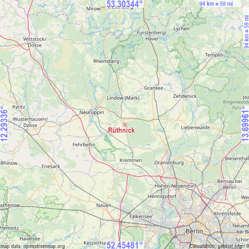
Rüthnick GPS coordinates[2]
52° 52' 52.32" North, 12° 59' 47.328" East
| Map corner | latitude | longitude |
|---|---|---|
| Upper-left | 53.30344°, | 12.29336° |
| Center: | 52.8812°, | 12.99648° |
| Lower-right: | 52.45481°, | 13.69961° |
| Map W x H: | 94.4×94.4 km | = 58.7×58.7mi |
| max Lat: | 55.01917° ⇑19.1% North |
| Rüthnick: | 52.8812° |
| min Lat: | ⇓80.9% South 47.40724° |
| min Long | Rüthnick | max Long |
| 5.92978° | 12.99648° | 14.98853° |
| W 92.3%⇐ | ⇒7.7% E |
Elevation
Elevation of Rüthnick is 43 m = 141 ft, and this is 206.1 m = 676 ft below average elevation for this country.
| Max E: |
1256 m = 4121 ft | 81.4% |
| Avg. | 249.1 m = 817 ft | |
| Rüthnick | 43 m = 141 ft | |
Min E: |
-5 m = -16 ft | 18.6% |
See also: Germany elevation on elevation.city.
Geographical zone
Rüthnick is located in North temperate zone (between Tropic of Cancer and the Arctic Circle). Distance of this North polar circle is 1521.3 km =945.3 mi to North.| Distance of | km | miles | from Rüthnick |
|---|---|---|---|
| North Pole | 4127.2 | 2564.5 | to North |
| Arctic Circle | 1521.3 | 945.3 | to North |
| Tropic Cancer | 3273.9 | 2034.3 | to South |
| Equator | 5879.8 | 3653.5 | to South |


Nearby cities:
15 places around Rüthnick: (largest is in red/bold)
• Dabergotz
18.4 km =11.4 mi,  277°
277°
• Fehrbellin
17.3 km =10.7 mi,  244°
244°
• Gransee
17.7 km =11 mi,  37°
37°
• Großwoltersdorf
21.8 km =13.5 mi,  18°
18°
• Herzberg
3 km =1.9 mi,  323°
323°
• Kremmen
13.4 km =8.3 mi,  171°
171°
• Leegebruch
22 km =13.7 mi,  143°
143°
• Lindow
9.6 km =6 mi,  355°
355°
• Neuruppin
14 km =8.7 mi,  291°
291°
• Oranienburg
21.6 km =13.4 mi,  130°
130°
• Schönermark
16.3 km =10.1 mi,  30°
30°
• Sonnenberg
16.5 km =10.3 mi, 21°
• Velten
24.3 km =15.1 mi,  150°
150°
• Walsleben
23.1 km =14.4 mi, 285°
• Zehdenick
24.9 km =15.5 mi,  64°
64°
Sources, notices
• [Note1] Compared only with cities in Germany existing in our database
• [Src1] Map data: © OpenStreetMap contributors (CC-BY-SA)
• [Src2] Other city data from geonames.org with taken over terms of usage.
• [Src3] Geographical zone / Annual Mean Temperature by Robert A. Rohde @ Wikipedia
