Cremlingen geodata
Cremlingen (Lower Saxony) is a seat of a fourth-order administrative division; located in Germany in Europe/Berlin (GMT+2) time zone. With population of 12,808 people, there are 1263 cities with bigger population in this country. Compared to other cities in Germany, 74.6% of cities are located further ↓South; 61.6% of cities are located further ←West and 66.2% of cities have higher elevation than Cremlingen. Note1
Administrative division(s):
- Level 1: Lower Saxony
- Level 3: Landkreis Wolfenbüttel
- Level 4: Cremlingen


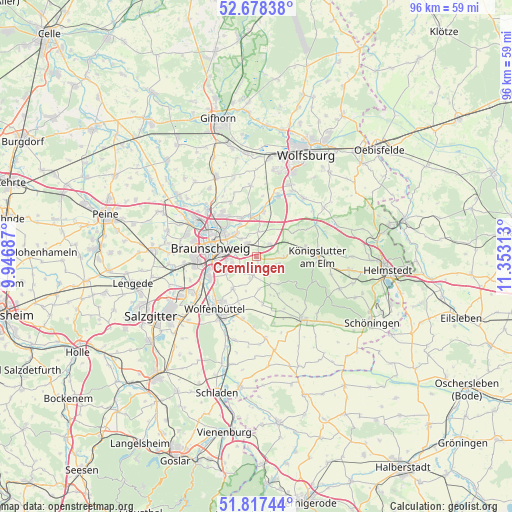
Cremlingen GPS coordinates[2]
52° 15' 0" North, 10° 39' 0" East
| Map corner | latitude | longitude |
|---|---|---|
| Upper-left | 52.67838°, | 9.94687° |
| Center: | 52.25°, | 10.65° |
| Lower-right: | 51.81744°, | 11.35313° |
| Map W x H: | 95.7×95.7 km | = 59.5×59.5mi |
| max Lat: | 55.01917° ⇑25.4% North |
| Cremlingen: | 52.25° |
| min Lat: | ⇓74.6% South 47.40724° |
| min Long | Cremlingen | max Long |
| 5.92978° | 10.65° | 14.98853° |
| W 61.6%⇐ | ⇒38.4% E |
Elevation
Elevation of Cremlingen is 113 m = 371 ft, and this is 136.1 m = 447 ft below average elevation for this country.
| Max E: |
1256 m = 4121 ft | 66.2% |
| Avg. | 249.1 m = 817 ft | |
| Cremlingen | 113 m = 371 ft | |
Min E: |
-5 m = -16 ft | 33.8% |
See also: Germany elevation on elevation.city.
Geographical zone
Cremlingen is located in North temperate zone (between Tropic of Cancer and the Arctic Circle). Distance of this North polar circle is 1591.5 km =988.9 mi to North.| Distance of | km | miles | from Cremlingen |
|---|---|---|---|
| North Pole | 4197.4 | 2608.1 | to North |
| Arctic Circle | 1591.5 | 988.9 | to North |
| Tropic Cancer | 3203.7 | 1990.7 | to South |
| Equator | 5809.7 | 3610 | to South |


Nearby cities:
15 places around Cremlingen: (largest is in red/bold)
• Abbesbüttel
13 km =8.1 mi,  330°
330°
• Bechtsbüttel
12.3 km =7.6 mi,  322°
322°
• Bevenrode
11.2 km =7 mi, 333°
• Braunschweig
8.6 km =5.3 mi,  281°
281°
• Destedt
4.3 km =2.7 mi,  107°
107°
• Dettum
8.7 km =5.4 mi,  171°
171°
• Erkerode
6.5 km =4 mi,  140°
140°
• Evessen
8 km =5 mi,  148°
148°
• Kneitlingen
11.3 km =7 mi, 137°
• Königslutter am Elm
11.4 km =7.1 mi,  89°
89°
• Lehre
9.3 km =5.8 mi,  6°
6°
• Leiferde
10.9 km =6.8 mi,  242°
242°
• Sickte
3.5 km =2.2 mi,  188°
188°
• Veltheim
4.1 km =2.5 mi, 146°
• Wolfenbüttel
12.1 km =7.5 mi,  217°
217°
Sources, notices
• [Note1] Compared only with cities in Germany existing in our database
• [Src1] Map data: © OpenStreetMap contributors (CC-BY-SA)
• [Src2] Other city data from geonames.org with taken over terms of usage.
• [Src3] Geographical zone / Annual Mean Temperature by Robert A. Rohde @ Wikipedia
