Carpin geodata
Carpin (Mecklenburg-Vorpommern) is a populated place; located in Germany in Europe/Berlin (GMT+2) time zone. With population of 1,025 people, there are 7091 cities with bigger population in this country. Compared to other cities in Germany, 84.2% of cities are located further ↓South; 93.9% of cities are located further ←West and 72.6% of cities have higher elevation than Carpin. Note1
Administrative division(s):
- Level 1: Mecklenburg-Vorpommern
- Level 3: Mecklenburgische Seenplatte
- Level 4: Carpin


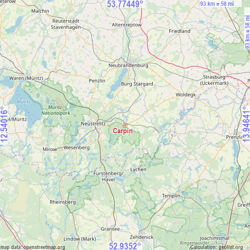
Carpin GPS coordinates[2]
53° 21' 24.876" North, 13° 14' 35.808" East
| Map corner | latitude | longitude |
|---|---|---|
| Upper-left | 53.77449°, | 12.54016° |
| Center: | 53.35691°, | 13.24328° |
| Lower-right: | 52.9352°, | 13.94641° |
| Map W x H: | 93.3×93.3 km | = 58×58mi |
| max Lat: | 55.01917° ⇑15.8% North |
| Carpin: | 53.35691° |
| min Lat: | ⇓84.2% South 47.40724° |
| min Long | Carpin | max Long |
| 5.92978° | 13.24328° | 14.98853° |
| W 93.9%⇐ | ⇒6.1% E |
Elevation
Elevation of Carpin is 74 m = 243 ft, and this is 175.1 m = 574 ft below average elevation for this country.
| Max E: |
1256 m = 4121 ft | 72.6% |
| Avg. | 249.1 m = 817 ft | |
| Carpin | 74 m = 243 ft | |
Min E: |
-5 m = -16 ft | 27.4% |
See also: Germany elevation on elevation.city.
Geographical zone
Carpin is located in North temperate zone (between Tropic of Cancer and the Arctic Circle). Distance of this North polar circle is 1468.4 km =912.4 mi to North.| Distance of | km | miles | from Carpin |
|---|---|---|---|
| North Pole | 4074.3 | 2531.7 | to North |
| Arctic Circle | 1468.4 | 912.4 | to North |
| Tropic Cancer | 3326.8 | 2067.2 | to South |
| Equator | 5932.7 | 3686.4 | to South |


Nearby cities:
15 places around Carpin: (largest is in red/bold)
• Blankensee
5.5 km =3.4 mi,  17°
17°
• Blumenholz
10.3 km =6.4 mi,  307°
307°
• Burg Stargard
16.1 km =10 mi, 16°
• Groß Nemerow
13 km =8.1 mi,  354°
354°
• Hohenzieritz
13.5 km =8.4 mi, 314°
• Holldorf
12.2 km =7.6 mi,  8°
8°
• Klein Vielen
17.8 km =11.1 mi, 306°
• Loitz
13.5 km =8.4 mi,  45°
45°
• Lychen
16.8 km =10.4 mi,  163°
163°
• Möllenbeck
7.5 km =4.7 mi,  61°
61°
• Neustrelitz
11.3 km =7 mi,  272°
272°
• Penzlin
19.5 km =12.1 mi,  327°
327°
• Teschendorf
13.5 km =8.4 mi,  34°
34°
• Userin
17.6 km =10.9 mi,  263°
263°
• Wustrow
14.6 km =9.1 mi,  336°
336°
Sources, notices
• [Note1] Compared only with cities in Germany existing in our database
• [Src1] Map data: © OpenStreetMap contributors (CC-BY-SA)
• [Src2] Other city data from geonames.org with taken over terms of usage.
• [Src3] Geographical zone / Annual Mean Temperature by Robert A. Rohde @ Wikipedia
