Möllenbeck geodata
Möllenbeck (Mecklenburg-Vorpommern) is a populated place; located in Germany in Europe/Berlin (GMT+2) time zone. With population of 805 people, there are 7875 cities with bigger population in this country. Compared to other cities in Germany, 84.4% of cities are located further ↓South; 94.7% of cities are located further ←West and 70.4% of cities have higher elevation than Möllenbeck. Note1
Administrative division(s):
- Level 1: Mecklenburg-Vorpommern
- Level 3: Mecklenburgische Seenplatte
- Level 4: Möllenbeck


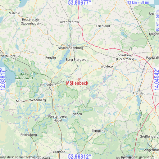
Möllenbeck GPS coordinates[2]
53° 23' 22.236" North, 13° 20' 32.244" East
| Map corner | latitude | longitude |
|---|---|---|
| Upper-left | 53.80677°, | 12.63917° |
| Center: | 53.38951°, | 13.34229° |
| Lower-right: | 52.96812°, | 14.04542° |
| Map W x H: | 93.2×93.2 km | = 57.9×57.9mi |
| max Lat: | 55.01917° ⇑15.6% North |
| Möllenbeck: | 53.38951° |
| min Lat: | ⇓84.4% South 47.40724° |
| min Long | Möllenbeck | max Long |
| 5.92978° | 13.34229° | 14.98853° |
| W 94.7%⇐ | ⇒5.3% E |
Elevation
Elevation of Möllenbeck is 89 m = 292 ft, and this is 160.1 m = 525 ft below average elevation for this country.
| Max E: |
1256 m = 4121 ft | 70.4% |
| Avg. | 249.1 m = 817 ft | |
| Möllenbeck | 89 m = 292 ft | |
Min E: |
-5 m = -16 ft | 29.6% |
See also: Germany elevation on elevation.city.
Geographical zone
Möllenbeck is located in North temperate zone (between Tropic of Cancer and the Arctic Circle). Distance of this North polar circle is 1464.8 km =910.2 mi to North.| Distance of | km | miles | from Möllenbeck |
|---|---|---|---|
| North Pole | 4070.7 | 2529.4 | to North |
| Arctic Circle | 1464.8 | 910.2 | to North |
| Tropic Cancer | 3330.4 | 2069.4 | to South |
| Equator | 5936.4 | 3688.7 | to South |


Nearby cities:
15 places around Möllenbeck: (largest is in red/bold)
• Blankensee
5.2 km =3.2 mi,  288°
288°
• Blumenholz
15 km =9.3 mi,  280°
280°
• Burg Stargard
12 km =7.5 mi,  350°
350°
• Carpin
7.5 km =4.7 mi,  241°
241°
• Cölpin
15.9 km =9.9 mi,  22°
22°
• Groß Nemerow
12.1 km =7.5 mi,  320°
320°
• Hohenzieritz
17.2 km =10.7 mi, 289°
• Holldorf
9.6 km =6 mi,  330°
330°
• Loitz
6.6 km =4.1 mi,  27°
27°
• Lychen
19.8 km =12.3 mi,  185°
185°
• Neustrelitz
18.1 km =11.2 mi,  260°
260°
• Pragsdorf
17 km =10.6 mi,  11°
11°
• Teschendorf
7.7 km =4.8 mi, 7°
• Woldegk
17.8 km =11.1 mi,  63°
63°
• Wustrow
15.8 km =9.8 mi,  308°
308°
Sources, notices
• [Note1] Compared only with cities in Germany existing in our database
• [Src1] Map data: © OpenStreetMap contributors (CC-BY-SA)
• [Src2] Other city data from geonames.org with taken over terms of usage.
• [Src3] Geographical zone / Annual Mean Temperature by Robert A. Rohde @ Wikipedia
