Lychen geodata
Lychen (Brandenburg) is a populated place; located in Germany in Europe/Berlin (GMT+2) time zone. With population of 3,917 people, there are 3342 cities with bigger population in this country. Compared to other cities in Germany, 82.9% of cities are located further ↓South; 94.5% of cities are located further ←West and 76.1% of cities have higher elevation than Lychen. Note1


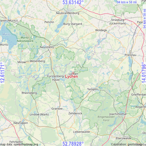
Lychen GPS coordinates[2]
53° 12' 44.712" North, 13° 18' 53.388" East
| Map corner | latitude | longitude |
|---|---|---|
| Upper-left | 53.63142°, | 12.61171° |
| Center: | 53.21242°, | 13.31483° |
| Lower-right: | 52.78928°, | 14.01796° |
| Map W x H: | 93.6×93.6 km | = 58.2×58.2mi |
| max Lat: | 55.01917° ⇑17.1% North |
| Lychen: | 53.21242° |
| min Lat: | ⇓82.9% South 47.40724° |
| min Long | Lychen | max Long |
| 5.92978° | 13.31483° | 14.98853° |
| W 94.5%⇐ | ⇒5.5% E |
Elevation
Elevation of Lychen is 59 m = 194 ft, and this is 190.1 m = 624 ft below average elevation for this country.
| Max E: |
1256 m = 4121 ft | 76.1% |
| Avg. | 249.1 m = 817 ft | |
| Lychen | 59 m = 194 ft | |
Min E: |
-5 m = -16 ft | 23.9% |
See also: Germany elevation on elevation.city.
Geographical zone
Lychen is located in North temperate zone (between Tropic of Cancer and the Arctic Circle). Distance of this North polar circle is 1484.5 km =922.4 mi to North.| Distance of | km | miles | from Lychen |
|---|---|---|---|
| North Pole | 4090.4 | 2541.7 | to North |
| Arctic Circle | 1484.5 | 922.4 | to North |
| Tropic Cancer | 3310.7 | 2057.2 | to South |
| Equator | 5916.7 | 3676.5 | to South |


Nearby cities:
15 places around Lychen: (largest is in red/bold)
• Blankensee
21.5 km =13.4 mi,  351°
351°
• Blumenholz
25.9 km =16.1 mi,  330°
330°
• Carpin
16.8 km =10.4 mi,  343°
343°
• Fürstenberg
11.8 km =7.3 mi,  254°
254°
• Gransee
25.1 km =15.6 mi,  204°
204°
• Großwoltersdorf
21.6 km =13.4 mi,  221°
221°
• Loitz
26 km =16.2 mi,  10°
10°
• Milmersdorf
24.5 km =15.2 mi,  117°
117°
• Mittenwalde
23.7 km =14.7 mi,  97°
97°
• Möllenbeck
19.8 km =12.3 mi, 5°
• Neustrelitz
23.1 km =14.4 mi,  315°
315°
• Schönermark
26.3 km =16.3 mi,  209°
209°
• Templin
16.3 km =10.1 mi,  129°
129°
• Wesenberg
24.2 km =15 mi,  288°
288°
• Zehdenick
26 km =16.2 mi,  177°
177°
Sources, notices
• [Note1] Compared only with cities in Germany existing in our database
• [Src1] Map data: © OpenStreetMap contributors (CC-BY-SA)
• [Src2] Other city data from geonames.org with taken over terms of usage.
• [Src3] Geographical zone / Annual Mean Temperature by Robert A. Rohde @ Wikipedia
