Buttenwiesen geodata
Buttenwiesen (Bavaria) is a seat of a fourth-order administrative division; located in Germany in Europe/Berlin (GMT+2) time zone. With population of 5,750 people, there are 2542 cities with bigger population in this country. Compared to other cities in Germany, 87.8% of cities are located further ↑North; 62.7% of cities are located further ←West and 76.5% of cities have lower elevation than Buttenwiesen. Note1
Administrative division(s):
- Level 1: Bavaria
- Level 2: Swabia
- Level 3: Landkreis Dillingen an der Donau
- Level 4: Buttenwiesen


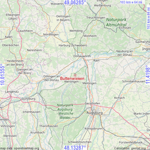
Buttenwiesen GPS coordinates[2]
48° 36' 0" North, 10° 43' 0.012" East
| Map corner | latitude | longitude |
|---|---|---|
| Upper-left | 49.06285°, | 10.01355° |
| Center: | 48.6°, | 10.71667° |
| Lower-right: | 48.13287°, | 11.4198° |
| Map W x H: | 103.4×103.4 km | = 64.2×64.2mi |
| max Lat: | 55.01917° ⇑87.8% North |
| Buttenwiesen: | 48.6° |
| min Lat: | ⇓12.2% South 47.40724° |
| min Long | Buttenwiesen | max Long |
| 5.92978° | 10.71667° | 14.98853° |
| W 62.7%⇐ | ⇒37.3% E |
Elevation
Elevation of Buttenwiesen is 409 m = 1342 ft, and this is 159.9 m = 525 ft above average elevation for this country.
| Max E: |
1256 m = 4121 ft | 23.5% |
| Buttenwiesen | 409 m 1342 ft | |
| Avg. | 249.1 m = 817 ft | |
Min E: |
-5 m = -16 ft | 76.5% |
See also: Germany elevation on elevation.city.
Geographical zone
Buttenwiesen is located in North temperate zone (between Tropic of Cancer and the Arctic Circle). Distance of this North polar circle is 1997.4 km =1241.1 mi to North.| Distance of | km | miles | from Buttenwiesen |
|---|---|---|---|
| North Pole | 4603.2 | 2860.3 | to North |
| Arctic Circle | 1997.4 | 1241.1 | to North |
| Tropic Cancer | 2797.9 | 1738.5 | to South |
| Equator | 5403.8 | 3357.8 | to South |


Nearby cities:
15 places around Buttenwiesen: (largest is in red/bold)
• Allmannshofen
7 km =4.3 mi,  78°
78°
• Binswangen
7.2 km =4.5 mi,  229°
229°
• Blindheim
7.9 km =4.9 mi,  296°
296°
• Ehingen
6.1 km =3.8 mi,  90°
90°
• Ellgau
11 km =6.8 mi, 90°
• Höchstädt an der Donau
11 km =6.8 mi,  276°
276°
• Kühlenthal
8.2 km =5.1 mi,  116°
116°
• Laugna
7.5 km =4.7 mi,  189°
189°
• Mertingen
9.1 km =5.7 mi,  45°
45°
• Nordendorf
8.5 km =5.3 mi, 93°
• Schwenningen
7.4 km =4.6 mi,  318°
318°
• Tapfheim
8.5 km =5.3 mi,  343°
343°
• Wertingen
4.8 km =3 mi,  212°
212°
• Westendorf
9.6 km =6 mi,  108°
108°
• Zusamaltheim
9.7 km =6 mi,  217°
217°
Sources, notices
• [Note1] Compared only with cities in Germany existing in our database
• [Src1] Map data: © OpenStreetMap contributors (CC-BY-SA)
• [Src2] Other city data from geonames.org with taken over terms of usage.
• [Src3] Geographical zone / Annual Mean Temperature by Robert A. Rohde @ Wikipedia
