Westendorf geodata
Westendorf (Bavaria) is a seat of a fourth-order administrative division; located in Germany in Europe/Berlin (GMT+2) time zone. With population of 1,489 people, there are 5904 cities with bigger population in this country. Compared to other cities in Germany, 88.2% of cities are located further ↑North; 64.7% of cities are located further ←West and 79% of cities have lower elevation than Westendorf. Note1
Administrative division(s):
- Level 1: Bavaria
- Level 2: Swabia
- Level 3: Landkreis Augsburg
- Level 4: Westendorf


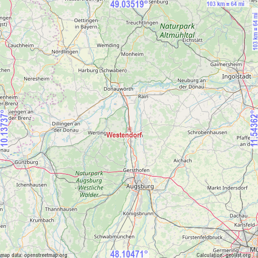
Westendorf GPS coordinates[2]
48° 34' 19.524" North, 10° 50' 25.764" East
| Map corner | latitude | longitude |
|---|---|---|
| Upper-left | 49.03519°, | 10.13737° |
| Center: | 48.57209°, | 10.84049° |
| Lower-right: | 48.10471°, | 11.54362° |
| Map W x H: | 103.5×103.5 km | = 64.3×64.3mi |
| max Lat: | 55.01917° ⇑88.2% North |
| Westendorf: | 48.57209° |
| min Lat: | ⇓11.8% South 47.40724° |
| min Long | Westendorf | max Long |
| 5.92978° | 10.84049° | 14.98853° |
| W 64.7%⇐ | ⇒35.3% E |
Elevation
Elevation of Westendorf is 427 m = 1401 ft, and this is 177.9 m = 584 ft above average elevation for this country.
| Max E: |
1256 m = 4121 ft | 21% |
| Westendorf | 427 m 1401 ft | |
| Avg. | 249.1 m = 817 ft | |
Min E: |
-5 m = -16 ft | 79% |
See also: Germany elevation on elevation.city.
Geographical zone
Westendorf is located in North temperate zone (between Tropic of Cancer and the Arctic Circle). Distance of this North polar circle is 2000.5 km =1243.1 mi to North.| Distance of | km | miles | from Westendorf |
|---|---|---|---|
| North Pole | 4606.4 | 2862.3 | to North |
| Arctic Circle | 2000.5 | 1243.1 | to North |
| Tropic Cancer | 2794.8 | 1736.6 | to South |
| Equator | 5400.7 | 3355.8 | to South |


Nearby cities:
15 places around Westendorf: (largest is in red/bold)
• Aindling
10.5 km =6.5 mi,  128°
128°
• Allmannshofen
5 km =3.1 mi,  332°
332°
• Biberbach
6.4 km =4 mi,  199°
199°
• Buttenwiesen
9.6 km =6 mi,  288°
288°
• Ehingen
4.3 km =2.7 mi,  316°
316°
• Ellgau
3.7 km =2.3 mi,  31°
31°
• Holzheim
9 km =5.6 mi,  61°
61°
• Kühlenthal
1.9 km =1.2 mi,  251°
251°
• Langweid
9.1 km =5.7 mi,  174°
174°
• Meitingen
3 km =1.9 mi,  164°
164°
• Mertingen
9.8 km =6.1 mi,  344°
344°
• Münster
7.2 km =4.5 mi,  38°
38°
• Nordendorf
2.6 km =1.6 mi,  345°
345°
• Thierhaupten
5.1 km =3.2 mi,  98°
98°
• Todtenweis
8.9 km =5.5 mi, 133°
Sources, notices
• [Note1] Compared only with cities in Germany existing in our database
• [Src1] Map data: © OpenStreetMap contributors (CC-BY-SA)
• [Src2] Other city data from geonames.org with taken over terms of usage.
• [Src3] Geographical zone / Annual Mean Temperature by Robert A. Rohde @ Wikipedia
