Burk geodata
Burk (Bavaria) is a seat of a fourth-order administrative division; located in Germany in Europe/Berlin (GMT+2) time zone. With population of 1,241 people, there are 6469 cities with bigger population in this country. Compared to other cities in Germany, 81.4% of cities are located further ↑North; 58.5% of cities are located further ←West and 83.9% of cities have lower elevation than Burk. Note1
Administrative division(s):
- Level 1: Bavaria
- Level 2: Regierungsbezirk Mittelfranken
- Level 3: Landkreis Ansbach
- Level 4: Burk


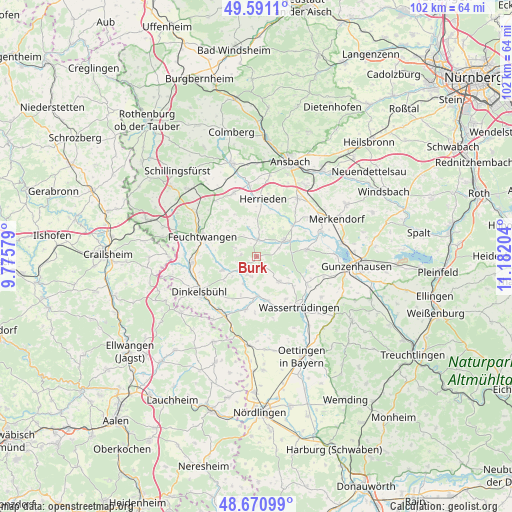
Burk GPS coordinates[2]
49° 7' 59.448" North, 10° 28' 44.076" East
| Map corner | latitude | longitude |
|---|---|---|
| Upper-left | 49.5911°, | 9.77579° |
| Center: | 49.13318°, | 10.47891° |
| Lower-right: | 48.67099°, | 11.18204° |
| Map W x H: | 102.3×102.3 km | = 63.6×63.6mi |
| max Lat: | 55.01917° ⇑81.4% North |
| Burk: | 49.13318° |
| min Lat: | ⇓18.6% South 47.40724° |
| min Long | Burk | max Long |
| 5.92978° | 10.47891° | 14.98853° |
| W 58.5%⇐ | ⇒41.5% E |
Elevation
Elevation of Burk is 461 m = 1512 ft, and this is 211.9 m = 695 ft above average elevation for this country.
| Max E: |
1256 m = 4121 ft | 16.1% |
| Burk | 461 m 1512 ft | |
| Avg. | 249.1 m = 817 ft | |
Min E: |
-5 m = -16 ft | 83.9% |
See also: Germany elevation on elevation.city.
Geographical zone
Burk is located in North temperate zone (between Tropic of Cancer and the Arctic Circle). Distance of this North polar circle is 1938.1 km =1204.3 mi to North.| Distance of | km | miles | from Burk |
|---|---|---|---|
| North Pole | 4544 | 2823.5 | to North |
| Arctic Circle | 1938.1 | 1204.3 | to North |
| Tropic Cancer | 2857.2 | 1775.4 | to South |
| Equator | 5463.1 | 3394.6 | to South |


Nearby cities:
15 places around Burk: (largest is in red/bold)
• Arberg
10.1 km =6.3 mi,  83°
83°
• Dentlein am Forst
4.4 km =2.7 mi,  291°
291°
• Dürrwangen
7.4 km =4.6 mi,  247°
247°
• Ehingen
6.8 km =4.2 mi,  138°
138°
• Feuchtwangen
10.7 km =6.6 mi, 287°
• Gerolfingen
9.2 km =5.7 mi,  165°
165°
• Herrieden
11.8 km =7.3 mi,  8°
8°
• Langfurth
4 km =2.5 mi,  207°
207°
• Lichtenau
7.8 km =4.8 mi, 292°
• Röckingen
10.5 km =6.5 mi,  145°
145°
• Schopfloch
12.6 km =7.8 mi,  262°
262°
• Unterschwaningen
12 km =7.5 mi,  119°
119°
• Weiltingen
10.7 km =6.6 mi,  191°
191°
• Wieseth
3.7 km =2.3 mi,  4°
4°
• Wittelshofen
8 km =5 mi,  178°
178°
Sources, notices
• [Note1] Compared only with cities in Germany existing in our database
• [Src1] Map data: © OpenStreetMap contributors (CC-BY-SA)
• [Src2] Other city data from geonames.org with taken over terms of usage.
• [Src3] Geographical zone / Annual Mean Temperature by Robert A. Rohde @ Wikipedia
