Dentlein am Forst geodata
Dentlein am Forst (Bavaria) is a populated place; located in Germany in Europe/Berlin (GMT+2) time zone. With population of 2,520 people, there are 4416 cities with bigger population in this country. Compared to other cities in Germany, 81.2% of cities are located further ↑North; 57.5% of cities are located further ←West and 86% of cities have lower elevation than Dentlein am Forst. Note1
Administrative division(s):
- Level 1: Bavaria
- Level 2: Regierungsbezirk Mittelfranken
- Level 3: Landkreis Ansbach
- Level 4: Dentlein a.Forst, Markt


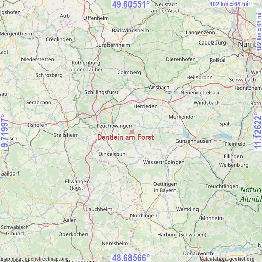
Dentlein am Forst GPS coordinates[2]
49° 8' 51.792" North, 10° 25' 23.124" East
| Map corner | latitude | longitude |
|---|---|---|
| Upper-left | 49.60551°, | 9.71997° |
| Center: | 49.14772°, | 10.42309° |
| Lower-right: | 48.68566°, | 11.12622° |
| Map W x H: | 102.3×102.3 km | = 63.6×63.6mi |
| max Lat: | 55.01917° ⇑81.2% North |
| Dentlein am Forst: | 49.14772° |
| min Lat: | ⇓18.8% South 47.40724° |
| min Long | Dentlein am For | max Long |
| 5.92978° | 10.42309° | 14.98853° |
| W 57.5%⇐ | ⇒42.5% E |
Elevation
Elevation of Dentlein am Forst is 478 m = 1568 ft, and this is 228.9 m = 751 ft above average elevation for this country.
| Max E: |
1256 m = 4121 ft | 14% |
| Dentlein am Forst | 478 m 1568 ft | |
| Avg. | 249.1 m = 817 ft | |
Min E: |
-5 m = -16 ft | 86% |
See also: Germany elevation on elevation.city.
Geographical zone
Dentlein am Forst is located in North temperate zone (between Tropic of Cancer and the Arctic Circle). Distance of this North polar circle is 1936.5 km =1203.3 mi to North.| Distance of | km | miles | from Dentlein am Forst |
|---|---|---|---|
| North Pole | 4542.3 | 2822.5 | to North |
| Arctic Circle | 1936.5 | 1203.3 | to North |
| Tropic Cancer | 2858.8 | 1776.4 | to South |
| Equator | 5464.7 | 3395.6 | to South |


Nearby cities:
15 places around Dentlein am Forst: (largest is in red/bold)
• Aurach
11.4 km =7.1 mi,  357°
357°
• Burk
4.4 km =2.7 mi,  111°
111°
• Dinkelsbühl
11.5 km =7.1 mi,  220°
220°
• Dürrwangen
5.2 km =3.2 mi,  211°
211°
• Ehingen
10.9 km =6.8 mi,  128°
128°
• Feuchtwangen
6.4 km =4 mi,  285°
285°
• Gerolfingen
12.3 km =7.6 mi,  148°
148°
• Herrieden
11.6 km =7.2 mi,  30°
30°
• Langfurth
5.6 km =3.5 mi,  156°
156°
• Lichtenau
3.5 km =2.2 mi, 292°
• Schopfloch
9 km =5.6 mi,  249°
249°
• Weiltingen
12.3 km =7.6 mi,  170°
170°
• Wieseth
4.9 km =3 mi,  64°
64°
• Wilburgstetten
13.9 km =8.6 mi,  188°
188°
• Wittelshofen
10.5 km =6.5 mi, 156°
Sources, notices
• [Note1] Compared only with cities in Germany existing in our database
• [Src1] Map data: © OpenStreetMap contributors (CC-BY-SA)
• [Src2] Other city data from geonames.org with taken over terms of usage.
• [Src3] Geographical zone / Annual Mean Temperature by Robert A. Rohde @ Wikipedia
