Brunnthal geodata
Brunnthal (Bavaria) is a seat of a fourth-order administrative division; located in Germany in Europe/Berlin (GMT+2) time zone. With population of 4,628 people, there are 2976 cities with bigger population in this country. Compared to other cities in Germany, 95.5% of cities are located further ↑North; 77% of cities are located further ←West and 94.7% of cities have lower elevation than Brunnthal. Note1
Administrative division(s):
- Level 1: Bavaria
- Level 2: Upper Bavaria
- Level 3: Landkreis München
- Level 4: Brunnthal


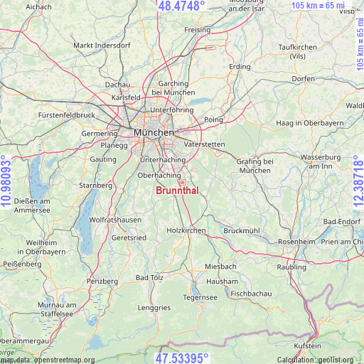
Brunnthal GPS coordinates[2]
48° 0' 23.472" North, 11° 41' 2.58" East
| Map corner | latitude | longitude |
|---|---|---|
| Upper-left | 48.4748°, | 10.98093° |
| Center: | 48.00652°, | 11.68405° |
| Lower-right: | 47.53395°, | 12.38718° |
| Map W x H: | 104.6×104.6 km | = 65×65mi |
| max Lat: | 55.01917° ⇑95.5% North |
| Brunnthal: | 48.00652° |
| min Lat: | ⇓4.5% South 47.40724° |
| min Long | Brunnthal | max Long |
| 5.92978° | 11.68405° | 14.98853° |
| W 77%⇐ | ⇒23% E |
Elevation
Elevation of Brunnthal is 593 m = 1946 ft, and this is 343.9 m = 1128 ft above average elevation for this country.
| Max E: |
1256 m = 4121 ft | 5.3% |
| Brunnthal | 593 m 1946 ft | |
| Avg. | 249.1 m = 817 ft | |
Min E: |
-5 m = -16 ft | 94.7% |
See also: Germany elevation on elevation.city.
Geographical zone
Brunnthal is located in North temperate zone (between Tropic of Cancer and the Arctic Circle). Distance of this North polar circle is 2063.3 km =1282.1 mi to North.| Distance of | km | miles | from Brunnthal |
|---|---|---|---|
| North Pole | 4669.2 | 2901.3 | to North |
| Arctic Circle | 2063.3 | 1282.1 | to North |
| Tropic Cancer | 2731.9 | 1697.5 | to South |
| Equator | 5337.8 | 3316.8 | to South |


Nearby cities:
15 places around Brunnthal: (largest is in red/bold)
• Aying
8 km =5 mi,  120°
120°
• Egmating
8.3 km =5.2 mi,  91°
91°
• Grasbrunn
9.2 km =5.7 mi,  28°
28°
• Haar
11.8 km =7.3 mi,  15°
15°
• Hohenbrunn
4.8 km =3 mi, 16°
• Höhenkirchen-Siegertsbrunn
3 km =1.9 mi,  61°
61°
• Neubiberg
8.1 km =5 mi,  346°
346°
• Oberhaching
6.7 km =4.2 mi,  287°
287°
• Oberpframmern
9.8 km =6.1 mi,  79°
79°
• Otterfing
10.9 km =6.8 mi,  183°
183°
• Ottobrunn
6.7 km =4.2 mi, 346°
• Putzbrunn
8.1 km =5 mi, 16°
• Sauerlach
4.5 km =2.8 mi,  210°
210°
• Taufkirchen
6.8 km =4.2 mi,  313°
313°
• Unterhaching
8.3 km =5.2 mi,  322°
322°
Sources, notices
• [Note1] Compared only with cities in Germany existing in our database
• [Src1] Map data: © OpenStreetMap contributors (CC-BY-SA)
• [Src2] Other city data from geonames.org with taken over terms of usage.
• [Src3] Geographical zone / Annual Mean Temperature by Robert A. Rohde @ Wikipedia
