Sauerlach geodata
Sauerlach (Bavaria) is a seat of a fourth-order administrative division; located in Germany in Europe/Berlin (GMT+2) time zone. With population of 5,991 people, there are 2467 cities with bigger population in this country. Compared to other cities in Germany, 95.8% of cities are located further ↑North; 76.6% of cities are located further ←West and 95.8% of cities have lower elevation than Sauerlach. Note1
Administrative division(s):
- Level 1: Bavaria
- Level 2: Upper Bavaria
- Level 3: Landkreis München
- Level 4: Sauerlach


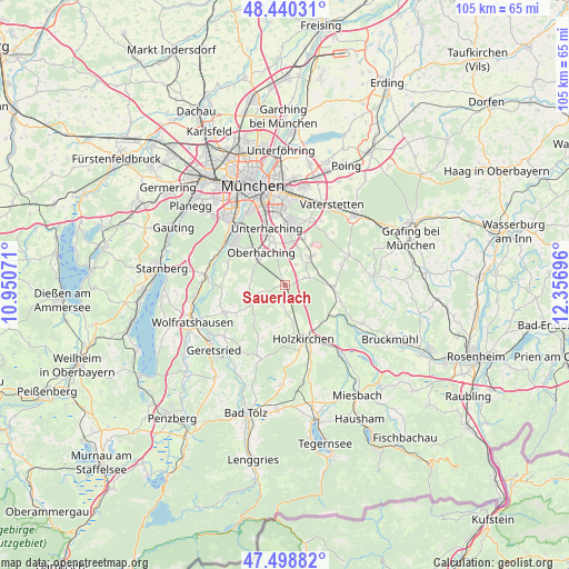
Sauerlach GPS coordinates[2]
47° 58' 18.156" North, 11° 39' 13.788" East
| Map corner | latitude | longitude |
|---|---|---|
| Upper-left | 48.44031°, | 10.95071° |
| Center: | 47.97171°, | 11.65383° |
| Lower-right: | 47.49882°, | 12.35696° |
| Map W x H: | 104.7×104.7 km | = 65.1×65.1mi |
| max Lat: | 55.01917° ⇑95.8% North |
| Sauerlach: | 47.97171° |
| min Lat: | ⇓4.2% South 47.40724° |
| min Long | Sauerlach | max Long |
| 5.92978° | 11.65383° | 14.98853° |
| W 76.6%⇐ | ⇒23.4% E |
Elevation
Elevation of Sauerlach is 619 m = 2031 ft, and this is 369.9 m = 1214 ft above average elevation for this country.
| Max E: |
1256 m = 4121 ft | 4.2% |
| Sauerlach | 619 m 2031 ft | |
| Avg. | 249.1 m = 817 ft | |
Min E: |
-5 m = -16 ft | 95.8% |
See also: Germany elevation on elevation.city.
Geographical zone
Sauerlach is located in North temperate zone (between Tropic of Cancer and the Arctic Circle). Distance of this North polar circle is 2067.2 km =1284.5 mi to North.| Distance of | km | miles | from Sauerlach |
|---|---|---|---|
| North Pole | 4673.1 | 2903.7 | to North |
| Arctic Circle | 2067.2 | 1284.5 | to North |
| Tropic Cancer | 2728 | 1695.1 | to South |
| Equator | 5334 | 3314.4 | to South |


Nearby cities:
15 places around Sauerlach: (largest is in red/bold)
• Aying
9.2 km =5.7 mi,  91°
91°
• Brunnthal
4.5 km =2.8 mi,  30°
30°
• Egling
12.3 km =7.6 mi,  244°
244°
• Egmating
11.1 km =6.9 mi,  71°
71°
• Hohenbrunn
9.2 km =5.7 mi,  23°
23°
• Holzkirchen
11.2 km =7 mi,  161°
161°
• Höhenkirchen-Siegertsbrunn
7.2 km =4.5 mi,  42°
42°
• Neubiberg
11.7 km =7.3 mi,  1°
1°
• Oberhaching
7.2 km =4.5 mi,  324°
324°
• Otterfing
7.2 km =4.5 mi,  166°
166°
• Ottobrunn
10.4 km =6.5 mi, 3°
• Reichertshausen
10.8 km =6.7 mi,  221°
221°
• Straßlach-Dingharting
11 km =6.8 mi,  289°
289°
• Taufkirchen
9 km =5.6 mi,  342°
342°
• Unterhaching
10.9 km =6.8 mi, 344°
Sources, notices
• [Note1] Compared only with cities in Germany existing in our database
• [Src1] Map data: © OpenStreetMap contributors (CC-BY-SA)
• [Src2] Other city data from geonames.org with taken over terms of usage.
• [Src3] Geographical zone / Annual Mean Temperature by Robert A. Rohde @ Wikipedia
