Brühl geodata
Brühl (Baden-Württemberg) is a seat of a fourth-order administrative division; located in Germany in Europe/Berlin (GMT+2) time zone. With population of 14,262 people, there are 1113 cities with bigger population in this country. Compared to other cities in Germany, 77.3% of cities are located further ↑North; 70.7% of cities are located further →East and 68.5% of cities have higher elevation than Brühl. Note1
Administrative division(s):
- Level 1: Baden-Württemberg
- Level 2: Karlsruhe Region
- Level 3: Rhein-Neckar-Kreis
- Level 4: Brühl


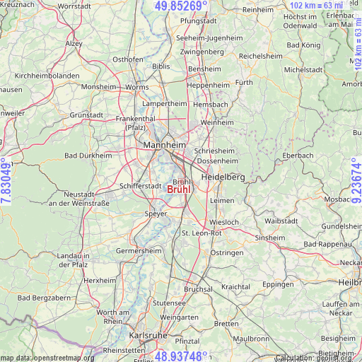
Brühl GPS coordinates[2]
49° 23' 49.992" North, 8° 32' 0.996" East
| Map corner | latitude | longitude |
|---|---|---|
| Upper-left | 49.85269°, | 7.83049° |
| Center: | 49.39722°, | 8.53361° |
| Lower-right: | 48.93748°, | 9.23674° |
| Map W x H: | 101.8×101.8 km | = 63.3×63.3mi |
| max Lat: | 55.01917° ⇑77.3% North |
| Brühl: | 49.39722° |
| min Lat: | ⇓22.7% South 47.40724° |
| min Long | Brühl | max Long |
| 5.92978° | 8.53361° | 14.98853° |
| W 29.3%⇐ | ⇒70.7% E |
Elevation
Elevation of Brühl is 100 m = 328 ft, and this is 149.1 m = 489 ft below average elevation for this country.
| Max E: |
1256 m = 4121 ft | 68.5% |
| Avg. | 249.1 m = 817 ft | |
| Brühl | 100 m = 328 ft | |
Min E: |
-5 m = -16 ft | 31.5% |
See also: Germany elevation on elevation.city.
Geographical zone
Brühl is located in North temperate zone (between Tropic of Cancer and the Arctic Circle). Distance of this North polar circle is 1908.7 km =1186 mi to North.| Distance of | km | miles | from Brühl |
|---|---|---|---|
| North Pole | 4514.6 | 2805.2 | to North |
| Arctic Circle | 1908.7 | 1186 | to North |
| Tropic Cancer | 2886.5 | 1793.6 | to South |
| Equator | 5492.5 | 3412.9 | to South |


Nearby cities:
15 places around Brühl: (largest is in red/bold)
• Altrip
5.1 km =3.2 mi,  326°
326°
• Edingen-Neckarhausen
8.5 km =5.3 mi,  38°
38°
• Eppelheim
7.5 km =4.7 mi,  85°
85°
• Hockenheim
8.3 km =5.2 mi,  170°
170°
• Ilvesheim
8.9 km =5.5 mi,  15°
15°
• Ketsch
3.3 km =2.1 mi,  183°
183°
• Ladenburg
10 km =6.2 mi,  32°
32°
• Limburgerhof
10.7 km =6.6 mi,  286°
286°
• Neuhofen
8.6 km =5.3 mi, 293°
• Oftersheim
5 km =3.1 mi,  134°
134°
• Otterstadt
6.8 km =4.2 mi,  245°
245°
• Plankstadt
4.5 km =2.8 mi, 93°
• Sandhausen
10.9 km =6.8 mi,  123°
123°
• Schwetzingen
3.9 km =2.4 mi, 115°
• Waldsee
6.8 km =4.2 mi,  268°
268°
Sources, notices
• [Note1] Compared only with cities in Germany existing in our database
• [Src1] Map data: © OpenStreetMap contributors (CC-BY-SA)
• [Src2] Other city data from geonames.org with taken over terms of usage.
• [Src3] Geographical zone / Annual Mean Temperature by Robert A. Rohde @ Wikipedia
