Hockenheim geodata
Hockenheim (Baden-Württemberg) is a populated place; located in Germany in Europe/Berlin (GMT+2) time zone. With population of 20,614 people, there are 745 cities with bigger population in this country. Compared to other cities in Germany, 78.3% of cities are located further ↑North; 70.6% of cities are located further →East and 67.6% of cities have higher elevation than Hockenheim. Note1
Administrative division(s):
- Level 1: Baden-Württemberg
- Level 2: Karlsruhe Region
- Level 3: Rhein-Neckar-Kreis
- Level 4: Hockenheim


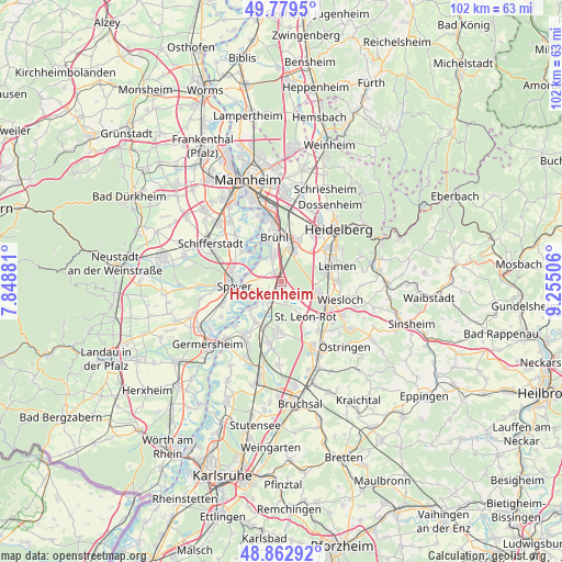
Hockenheim GPS coordinates[2]
49° 19' 24.024" North, 8° 33' 6.984" East
| Map corner | latitude | longitude |
|---|---|---|
| Upper-left | 49.7795°, | 7.84881° |
| Center: | 49.32334°, | 8.55194° |
| Lower-right: | 48.86292°, | 9.25506° |
| Map W x H: | 101.9×101.9 km | = 63.3×63.3mi |
| max Lat: | 55.01917° ⇑78.3% North |
| Hockenheim: | 49.32334° |
| min Lat: | ⇓21.7% South 47.40724° |
| min Long | Hockenheim | max Long |
| 5.92978° | 8.55194° | 14.98853° |
| W 29.4%⇐ | ⇒70.6% E |
Elevation
Elevation of Hockenheim is 104 m = 341 ft, and this is 145.1 m = 476 ft below average elevation for this country.
| Max E: |
1256 m = 4121 ft | 67.6% |
| Avg. | 249.1 m = 817 ft | |
| Hockenheim | 104 m = 341 ft | |
Min E: |
-5 m = -16 ft | 32.4% |
See also: Germany elevation on elevation.city.
Geographical zone
Hockenheim is located in North temperate zone (between Tropic of Cancer and the Arctic Circle). Distance of this North polar circle is 1916.9 km =1191.1 mi to North.| Distance of | km | miles | from Hockenheim |
|---|---|---|---|
| North Pole | 4522.8 | 2810.3 | to North |
| Arctic Circle | 1916.9 | 1191.1 | to North |
| Tropic Cancer | 2878.3 | 1788.5 | to South |
| Equator | 5484.2 | 3407.7 | to South |


Nearby cities:
15 places around Hockenheim: (largest is in red/bold)
• Altlußheim
4.5 km =2.8 mi,  237°
237°
• Brühl
8.3 km =5.2 mi,  350°
350°
• Ketsch
5.2 km =3.2 mi,  343°
343°
• Neulußheim
3.7 km =2.3 mi,  220°
220°
• Oberhausen-Rheinhausen
8 km =5 mi,  226°
226°
• Oftersheim
5.2 km =3.2 mi,  25°
25°
• Otterstadt
9.3 km =5.8 mi,  305°
305°
• Plankstadt
8.5 km =5.3 mi,  22°
22°
• Reilingen
2.9 km =1.8 mi,  162°
162°
• Sandhausen
8.1 km =5 mi,  74°
74°
• Sankt Leon-Rot
8 km =5 mi,  143°
143°
• Schwetzingen
6.9 km =4.3 mi, 18°
• Speyer
8.8 km =5.5 mi,  268°
268°
• Waghäusel
8.6 km =5.3 mi,  199°
199°
• Walldorf
6.8 km =4.2 mi,  106°
106°
Sources, notices
• [Note1] Compared only with cities in Germany existing in our database
• [Src1] Map data: © OpenStreetMap contributors (CC-BY-SA)
• [Src2] Other city data from geonames.org with taken over terms of usage.
• [Src3] Geographical zone / Annual Mean Temperature by Robert A. Rohde @ Wikipedia
