Bruckberg geodata
Bruckberg (Bavaria) is a seat of a fourth-order administrative division; located in Germany in Europe/Berlin (GMT+2) time zone. With population of 1,394 people, there are 6090 cities with bigger population in this country. Compared to other cities in Germany, 77.7% of cities are located further ↑North; 62.4% of cities are located further ←West and 67.6% of cities have lower elevation than Bruckberg. Note1
Administrative division(s):
- Level 1: Bavaria
- Level 2: Regierungsbezirk Mittelfranken
- Level 3: Landkreis Ansbach
- Level 4: Bruckberg


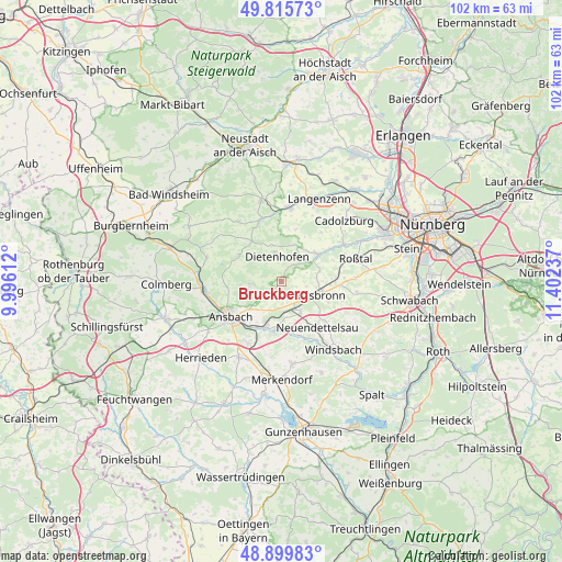
Bruckberg GPS coordinates[2]
49° 21' 35.676" North, 10° 41' 57.264" East
| Map corner | latitude | longitude |
|---|---|---|
| Upper-left | 49.81573°, | 9.99612° |
| Center: | 49.35991°, | 10.69924° |
| Lower-right: | 48.89983°, | 11.40237° |
| Map W x H: | 101.8×101.8 km | = 63.3×63.3mi |
| max Lat: | 55.01917° ⇑77.7% North |
| Bruckberg: | 49.35991° |
| min Lat: | ⇓22.3% South 47.40724° |
| min Long | Bruckberg | max Long |
| 5.92978° | 10.69924° | 14.98853° |
| W 62.4%⇐ | ⇒37.6% E |
Elevation
Elevation of Bruckberg is 340 m = 1115 ft, and this is 90.9 m = 298 ft above average elevation for this country.
| Max E: |
1256 m = 4121 ft | 32.4% |
| Bruckberg | 340 m 1115 ft | |
| Avg. | 249.1 m = 817 ft | |
Min E: |
-5 m = -16 ft | 67.6% |
See also: Germany elevation on elevation.city.
Geographical zone
Bruckberg is located in North temperate zone (between Tropic of Cancer and the Arctic Circle). Distance of this North polar circle is 1912.9 km =1188.6 mi to North.| Distance of | km | miles | from Bruckberg |
|---|---|---|---|
| North Pole | 4518.8 | 2807.9 | to North |
| Arctic Circle | 1912.9 | 1188.6 | to North |
| Tropic Cancer | 2882.4 | 1791 | to South |
| Equator | 5488.3 | 3410.3 | to South |


Nearby cities:
15 places around Bruckberg: (largest is in red/bold)
• Adelsdorf
12.3 km =7.6 mi,  355°
355°
• Ammerndorf
13 km =8.1 mi,  57°
57°
• Ansbach
9.8 km =6.1 mi,  231°
231°
• Dietenhofen
4.5 km =2.8 mi,  351°
351°
• Großhabersdorf
7.5 km =4.7 mi,  53°
53°
• Heilsbronn
6.9 km =4.3 mi,  112°
112°
• Lehrberg
13.7 km =8.5 mi,  263°
263°
• Neuendettelsau
10.5 km =6.5 mi,  144°
144°
• Neuhof an der Zenn
11.5 km =7.1 mi,  340°
340°
• Petersaurach
7.6 km =4.7 mi,  151°
151°
• Rügland
9.5 km =5.9 mi,  297°
297°
• Sachsen
8.3 km =5.2 mi,  200°
200°
• Trautskirchen
13.3 km =8.3 mi,  325°
325°
• Weihenzell
6.1 km =3.8 mi, 259°
• Wilhermsdorf
13.7 km =8.5 mi,  4°
4°
Sources, notices
• [Note1] Compared only with cities in Germany existing in our database
• [Src1] Map data: © OpenStreetMap contributors (CC-BY-SA)
• [Src2] Other city data from geonames.org with taken over terms of usage.
• [Src3] Geographical zone / Annual Mean Temperature by Robert A. Rohde @ Wikipedia
