Neuhof an der Zenn geodata
Neuhof an der Zenn (Bavaria) is a populated place; located in Germany in Europe/Berlin (GMT+2) time zone. With population of 2,091 people, there are 4938 cities with bigger population in this country. Compared to other cities in Germany, 76.4% of cities are located further ↑North; 61.5% of cities are located further ←West and 66.2% of cities have lower elevation than Neuhof an der Zenn. Note1
Administrative division(s):
- Level 1: Bavaria
- Level 2: Regierungsbezirk Mittelfranken
- Level 3: Landkreis Neustadt an der Aisch-Bad Windsheim
- Level 4: Neuhof a.d.Zenn, Markt


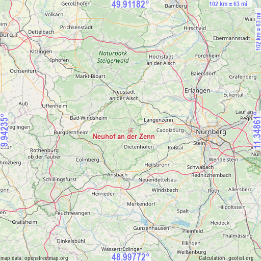
Neuhof an der Zenn GPS coordinates[2]
49° 27' 24.84" North, 10° 38' 43.728" East
| Map corner | latitude | longitude |
|---|---|---|
| Upper-left | 49.91182°, | 9.94235° |
| Center: | 49.4569°, | 10.64548° |
| Lower-right: | 48.99772°, | 11.34861° |
| Map W x H: | 101.6×101.6 km | = 63.1×63.1mi |
| max Lat: | 55.01917° ⇑76.4% North |
| Neuhof an der Zenn: | 49.4569° |
| min Lat: | ⇓23.6% South 47.40724° |
| min Long | Neuhof an der Z | max Long |
| 5.92978° | 10.64548° | 14.98853° |
| W 61.5%⇐ | ⇒38.5% E |
Elevation
Elevation of Neuhof an der Zenn is 330 m = 1083 ft, and this is 80.9 m = 265 ft above average elevation for this country.
| Max E: |
1256 m = 4121 ft | 33.8% |
| Neuhof an der Zenn | 330 m 1083 ft | |
| Avg. | 249.1 m = 817 ft | |
Min E: |
-5 m = -16 ft | 66.2% |
See also: Germany elevation on elevation.city.
Geographical zone
Neuhof an der Zenn is located in North temperate zone (between Tropic of Cancer and the Arctic Circle). Distance of this North polar circle is 1902.1 km =1181.9 mi to North.| Distance of | km | miles | from Neuhof an der Zenn |
|---|---|---|---|
| North Pole | 4508 | 2801.1 | to North |
| Arctic Circle | 1902.1 | 1181.9 | to North |
| Tropic Cancer | 2893.2 | 1797.8 | to South |
| Equator | 5499.1 | 3417 | to South |


Nearby cities:
15 places around Neuhof an der Zenn: (largest is in red/bold)
• Adelsdorf
3.2 km =2 mi,  62°
62°
• Bruckberg
11.5 km =7.1 mi,  160°
160°
• Dietenhofen
7.1 km =4.4 mi,  153°
153°
• Dietersheim
13.4 km =8.3 mi,  325°
325°
• Emskirchen
11.7 km =7.3 mi,  24°
24°
• Flachslanden
11.6 km =7.2 mi,  235°
235°
• Großhabersdorf
11.8 km =7.3 mi,  122°
122°
• Hagenbüchach
12.2 km =7.6 mi,  45°
45°
• Langenzenn
11.4 km =7.1 mi,  68°
68°
• Markt Erlbach
4.1 km =2.5 mi,  7°
7°
• Obernzenn
12.9 km =8 mi,  267°
267°
• Rügland
7.8 km =4.8 mi,  215°
215°
• Trautskirchen
3.8 km =2.4 mi, 272°
• Weihenzell
12.1 km =7.5 mi,  189°
189°
• Wilhermsdorf
5.8 km =3.6 mi, 60°
Sources, notices
• [Note1] Compared only with cities in Germany existing in our database
• [Src1] Map data: © OpenStreetMap contributors (CC-BY-SA)
• [Src2] Other city data from geonames.org with taken over terms of usage.
• [Src3] Geographical zone / Annual Mean Temperature by Robert A. Rohde @ Wikipedia
