Delmenhorst geodata
Delmenhorst (Lower Saxony) is a seat of a third-order administrative division; located in Germany in Europe/Berlin (GMT+2) time zone. With population of 75,893 people, there are 136 cities with bigger population in this country. Compared to other cities in Germany, 82% of cities are located further ↓South; 69.8% of cities are located further →East and 94.3% of cities have higher elevation than Delmenhorst. Note1
Administrative division(s):
- Level 1: Lower Saxony
- Level 3: Kreisfreie Stadt Delmenhorst
- Level 4: Delmenhorst


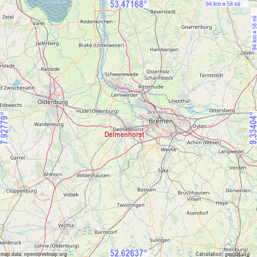
Delmenhorst GPS coordinates[2]
53° 3' 3.96" North, 8° 37' 51.276" East
| Map corner | latitude | longitude |
|---|---|---|
| Upper-left | 53.47168°, | 7.92779° |
| Center: | 53.0511°, | 8.63091° |
| Lower-right: | 52.62637°, | 9.33404° |
| Map W x H: | 94×94 km | = 58.4×58.4mi |
| max Lat: | 55.01917° ⇑18% North |
| Delmenhorst: | 53.0511° |
| min Lat: | ⇓82% South 47.40724° |
| min Long | Delmenhorst | max Long |
| 5.92978° | 8.63091° | 14.98853° |
| W 30.2%⇐ | ⇒69.8% E |
Elevation
Elevation of Delmenhorst is 10 m = 33 ft, and this is 239.1 m = 784 ft below average elevation for this country.
| Max E: |
1256 m = 4121 ft | 94.3% |
| Avg. | 249.1 m = 817 ft | |
| Delmenhorst | 10 m = 33 ft | |
Min E: |
-5 m = -16 ft | 5.7% |
See also: Delmenhorst elevation on elevation.city.
Geographical zone
Delmenhorst is located in North temperate zone (between Tropic of Cancer and the Arctic Circle). Distance of this North polar circle is 1502.4 km =933.5 mi to North.| Distance of | km | miles | from Delmenhorst |
|---|---|---|---|
| North Pole | 4108.3 | 2552.8 | to North |
| Arctic Circle | 1502.4 | 933.5 | to North |
| Tropic Cancer | 3292.8 | 2046.1 | to South |
| Equator | 5898.7 | 3665.3 | to South |


Nearby cities:
15 places around Delmenhorst: (largest is in red/bold)
• Bremen
12.1 km =7.5 mi,  77°
77°
• Burglesum
13.3 km =8.3 mi,  16°
16°
• Dünsen
13.8 km =8.6 mi,  176°
176°
• Ganderkesee
6.8 km =4.2 mi,  253°
253°
• Groß Ippener
9.4 km =5.8 mi,  185°
185°
• Harpstedt
16 km =9.9 mi, 189°
• Hatten
16.5 km =10.3 mi,  269°
269°
• Hude
12.8 km =8 mi,  299°
299°
• Kirchseelte
11.8 km =7.3 mi,  162°
162°
• Lemwerder
12.9 km =8 mi,  355°
355°
• Prinzhöfte
12 km =7.5 mi,  200°
200°
• Ritterhude
16.2 km =10.1 mi,  25°
25°
• Stuhr
8.2 km =5.1 mi,  103°
103°
• Syke
20 km =12.4 mi,  140°
140°
• Vegesack
12.9 km =8 mi, 355°
Sources, notices
• [Note1] Compared only with cities in Germany existing in our database
• [Src1] Map data: © OpenStreetMap contributors (CC-BY-SA)
• [Src2] Other city data from geonames.org with taken over terms of usage.
• [Src3] Geographical zone / Annual Mean Temperature by Robert A. Rohde @ Wikipedia
