Rottleberode geodata
Rottleberode (Saxony-Anhalt) is a populated place; located in Germany in Europe/Berlin (GMT+2) time zone. With population of 1,599 people, there are 5690 cities with bigger population in this country. Compared to other cities in Germany, 66.5% of cities are located further ↓South; 66.2% of cities are located further ←West and 52.9% of cities have higher elevation than Rottleberode. Note1


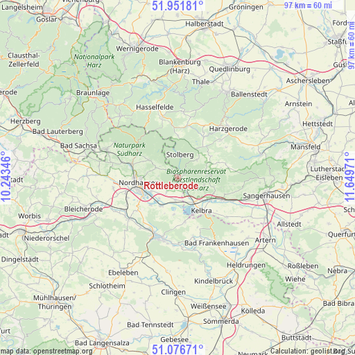
Rottleberode GPS coordinates[2]
51° 30' 58.896" North, 10° 56' 47.688" East
| Map corner | latitude | longitude |
|---|---|---|
| Upper-left | 51.95181°, | 10.24346° |
| Center: | 51.51636°, | 10.94658° |
| Lower-right: | 51.07671°, | 11.64971° |
| Map W x H: | 97.3×97.3 km | = 60.5×60.5mi |
| max Lat: | 55.01917° ⇑33.5% North |
| Rottleberode: | 51.51636° |
| min Lat: | ⇓66.5% South 47.40724° |
| min Long | Rottleberode | max Long |
| 5.92978° | 10.94658° | 14.98853° |
| W 66.2%⇐ | ⇒33.8% E |
Elevation
Elevation of Rottleberode is 205 m = 673 ft, and this is 44.1 m = 145 ft below average elevation for this country.
| Max E: |
1256 m = 4121 ft | 52.9% |
| Avg. | 249.1 m = 817 ft | |
| Rottleberode | 205 m = 673 ft | |
Min E: |
-5 m = -16 ft | 47.1% |
See also: Germany elevation on elevation.city.
Geographical zone
Rottleberode is located in North temperate zone (between Tropic of Cancer and the Arctic Circle). Distance of this North polar circle is 1673.1 km =1039.6 mi to North.| Distance of | km | miles | from Rottleberode |
|---|---|---|---|
| North Pole | 4279 | 2658.8 | to North |
| Arctic Circle | 1673.1 | 1039.6 | to North |
| Tropic Cancer | 3122.2 | 1940 | to South |
| Equator | 5728.1 | 3559.3 | to South |


Nearby cities:
15 places around Rottleberode: (largest is in red/bold)
• Auleben
10.1 km =6.3 mi,  186°
186°
• Berga
7.9 km =4.9 mi,  148°
148°
• Breitungen
7.6 km =4.7 mi,  105°
105°
• Buchholz
5.8 km =3.6 mi,  288°
288°
• Görsbach
6.1 km =3.8 mi, 186°
• Heringen
9.1 km =5.7 mi,  212°
212°
• Herrmannsacker
6.7 km =4.2 mi,  304°
304°
• Neustadt/Harz
9.6 km =6 mi,  305°
305°
• Nordhausen
10.6 km =6.6 mi,  261°
261°
• Schwenda
7.1 km =4.4 mi,  46°
46°
• Stolberg
6.5 km =4 mi,  5°
5°
• Uftrungen
3.1 km =1.9 mi,  129°
129°
• Urbach
5.1 km =3.2 mi,  217°
217°
• Uthleben
10.6 km =6.6 mi,  225°
225°
• Windehausen
7.6 km =4.7 mi, 222°
Sources, notices
• [Note1] Compared only with cities in Germany existing in our database
• [Src1] Map data: © OpenStreetMap contributors (CC-BY-SA)
• [Src2] Other city data from geonames.org with taken over terms of usage.
• [Src3] Geographical zone / Annual Mean Temperature by Robert A. Rohde @ Wikipedia
