Breitengüßbach geodata
Breitengüßbach (Bavaria) is a seat of a fourth-order administrative division; located in Germany in Europe/Berlin (GMT+2) time zone. With population of 4,643 people, there are 2968 cities with bigger population in this country. Compared to other cities in Germany, 64.5% of cities are located further ↑North; 65.3% of cities are located further ←West and 53.1% of cities have lower elevation than Breitengüßbach. Note1
Administrative division(s):
- Level 1: Bavaria
- Level 2: Upper Franconia
- Level 3: Landkreis Bamberg
- Level 4: Breitengüßbach


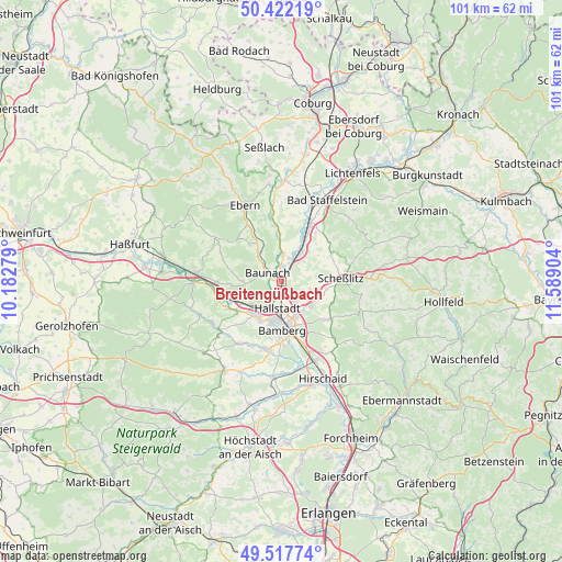
Breitengüßbach GPS coordinates[2]
49° 58' 19.524" North, 10° 53' 9.276" East
| Map corner | latitude | longitude |
|---|---|---|
| Upper-left | 50.42219°, | 10.18279° |
| Center: | 49.97209°, | 10.88591° |
| Lower-right: | 49.51774°, | 11.58904° |
| Map W x H: | 100.6×100.6 km | = 62.5×62.5mi |
| max Lat: | 55.01917° ⇑64.5% North |
| Breitengüßbach: | 49.97209° |
| min Lat: | ⇓35.5% South 47.40724° |
| min Long | Breitengüßbac | max Long |
| 5.92978° | 10.88591° | 14.98853° |
| W 65.3%⇐ | ⇒34.7% E |
Elevation
Elevation of Breitengüßbach is 247 m = 810 ft, and this is 2.1 m = 7 ft below average elevation for this country.
| Max E: |
1256 m = 4121 ft | 46.9% |
| Avg. | 249.1 m = 817 ft | |
| Breitengüßbach | 247 m = 810 ft | |
Min E: |
-5 m = -16 ft | 53.1% |
See also: Germany elevation on elevation.city.
Geographical zone
Breitengüßbach is located in North temperate zone (between Tropic of Cancer and the Arctic Circle). Distance of this North polar circle is 1844.8 km =1146.3 mi to North.| Distance of | km | miles | from Breitengüßbach |
|---|---|---|---|
| North Pole | 4450.7 | 2765.5 | to North |
| Arctic Circle | 1844.8 | 1146.3 | to North |
| Tropic Cancer | 2950.5 | 1833.4 | to South |
| Equator | 5556.4 | 3452.6 | to South |


Nearby cities:
15 places around Breitengüßbach: (largest is in red/bold)
• Bamberg
8.2 km =5.1 mi,  172°
172°
• Baunach
2.9 km =1.8 mi,  302°
302°
• Bischberg
7.8 km =4.8 mi,  209°
209°
• Gerach
9.2 km =5.7 mi,  317°
317°
• Gundelsheim
4.6 km =2.9 mi,  148°
148°
• Hallstadt
4.8 km =3 mi,  188°
188°
• Kemmern
2 km =1.2 mi,  196°
196°
• Lauter
7 km =4.3 mi,  270°
270°
• Memmelsdorf
7 km =4.3 mi,  131°
131°
• Oberhaid
6.7 km =4.2 mi,  229°
229°
• Rattelsdorf
4.8 km =3 mi,  2°
2°
• Reckendorf
6.2 km =3.9 mi, 322°
• Scheßlitz
10.5 km =6.5 mi,  87°
87°
• Viereth-Trunstadt
9.6 km =6 mi, 234°
• Zapfendorf
6.1 km =3.8 mi,  33°
33°
Sources, notices
• [Note1] Compared only with cities in Germany existing in our database
• [Src1] Map data: © OpenStreetMap contributors (CC-BY-SA)
• [Src2] Other city data from geonames.org with taken over terms of usage.
• [Src3] Geographical zone / Annual Mean Temperature by Robert A. Rohde @ Wikipedia
