Rattelsdorf geodata
Rattelsdorf (Bavaria) is a populated place; located in Germany in Europe/Berlin (GMT+2) time zone. With population of 4,550 people, there are 3010 cities with bigger population in this country. Compared to other cities in Germany, 63.5% of cities are located further ↑North; 65.4% of cities are located further ←West and 55.2% of cities have lower elevation than Rattelsdorf. Note1
Administrative division(s):
- Level 1: Bavaria
- Level 2: Upper Franconia
- Level 3: Landkreis Bamberg
- Level 4: Rattelsdorf, Markt


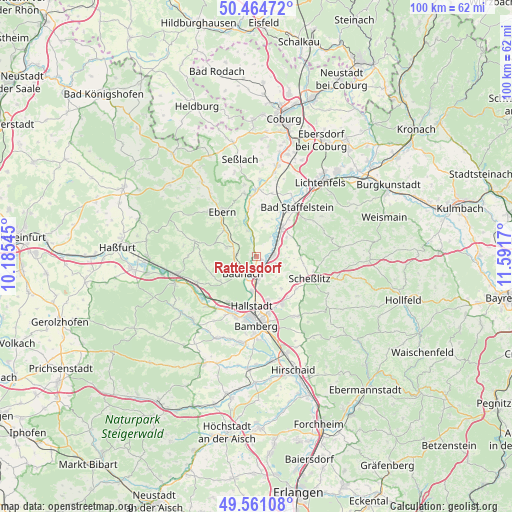
Rattelsdorf GPS coordinates[2]
50° 0' 54.072" North, 10° 53' 18.852" East
| Map corner | latitude | longitude |
|---|---|---|
| Upper-left | 50.46472°, | 10.18545° |
| Center: | 50.01502°, | 10.88857° |
| Lower-right: | 49.56108°, | 11.5917° |
| Map W x H: | 100.5×100.5 km | = 62.4×62.4mi |
| max Lat: | 55.01917° ⇑63.5% North |
| Rattelsdorf: | 50.01502° |
| min Lat: | ⇓36.5% South 47.40724° |
| min Long | Rattelsdorf | max Long |
| 5.92978° | 10.88857° | 14.98853° |
| W 65.4%⇐ | ⇒34.6% E |
Elevation
Elevation of Rattelsdorf is 259 m = 850 ft, and this is 9.9 m = 32 ft above average elevation for this country.
| Max E: |
1256 m = 4121 ft | 44.8% |
| Rattelsdorf | 259 m 850 ft | |
| Avg. | 249.1 m = 817 ft | |
Min E: |
-5 m = -16 ft | 55.2% |
See also: Germany elevation on elevation.city.
Geographical zone
Rattelsdorf is located in North temperate zone (between Tropic of Cancer and the Arctic Circle). Distance of this North polar circle is 1840 km =1143.3 mi to North.| Distance of | km | miles | from Rattelsdorf |
|---|---|---|---|
| North Pole | 4445.9 | 2762.6 | to North |
| Arctic Circle | 1840 | 1143.3 | to North |
| Tropic Cancer | 2955.2 | 1836.3 | to South |
| Equator | 5561.1 | 3455.5 | to South |


Nearby cities:
15 places around Rattelsdorf: (largest is in red/bold)
• Baunach
4.2 km =2.6 mi,  219°
219°
• Bischberg
12.3 km =7.6 mi,  199°
199°
• Breitengüßbach
4.8 km =3 mi,  182°
182°
• Ebensfeld
7.6 km =4.7 mi,  41°
41°
• Gerach
6.6 km =4.1 mi,  287°
287°
• Gundelsheim
9 km =5.6 mi,  165°
165°
• Hallstadt
9.6 km =6 mi,  185°
185°
• Kemmern
6.7 km =4.2 mi, 186°
• Lauter
8.5 km =5.3 mi,  236°
236°
• Memmelsdorf
10.7 km =6.6 mi,  151°
151°
• Oberhaid
10.6 km =6.6 mi,  209°
209°
• Reckendorf
4 km =2.5 mi,  272°
272°
• Rentweinsdorf
8.3 km =5.2 mi,  310°
310°
• Scheßlitz
11.2 km =7 mi,  112°
112°
• Zapfendorf
3.1 km =1.9 mi,  84°
84°
Sources, notices
• [Note1] Compared only with cities in Germany existing in our database
• [Src1] Map data: © OpenStreetMap contributors (CC-BY-SA)
• [Src2] Other city data from geonames.org with taken over terms of usage.
• [Src3] Geographical zone / Annual Mean Temperature by Robert A. Rohde @ Wikipedia
