Salzmünde geodata
Salzmünde (Saxony-Anhalt) is a populated place; located in Germany in Europe/Berlin (GMT+2) time zone. With population of 2,536 people, there are 4396 cities with bigger population in this country. Compared to other cities in Germany, 66.6% of cities are located further ↓South; 79.2% of cities are located further ←West and 72.6% of cities have higher elevation than Salzmünde. Note1


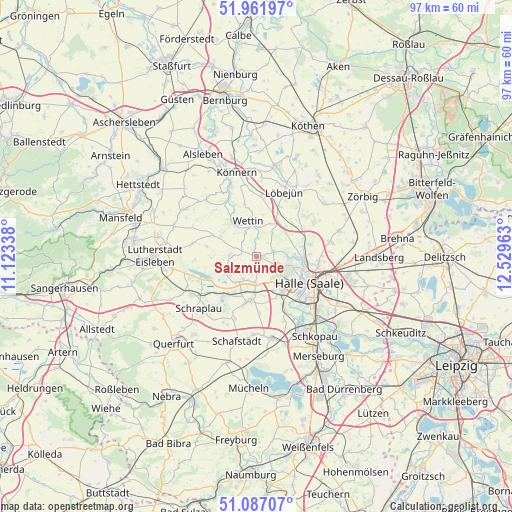
Salzmünde GPS coordinates[2]
51° 31' 35.832" North, 11° 49' 35.4" East
| Map corner | latitude | longitude |
|---|---|---|
| Upper-left | 51.96197°, | 11.12338° |
| Center: | 51.52662°, | 11.8265° |
| Lower-right: | 51.08707°, | 12.52963° |
| Map W x H: | 97.3×97.3 km | = 60.5×60.5mi |
| max Lat: | 55.01917° ⇑33.4% North |
| Salzmünde: | 51.52662° |
| min Lat: | ⇓66.6% South 47.40724° |
| min Long | Salzmünde | max Long |
| 5.92978° | 11.8265° | 14.98853° |
| W 79.2%⇐ | ⇒20.8% E |
Elevation
Elevation of Salzmünde is 74 m = 243 ft, and this is 175.1 m = 574 ft below average elevation for this country.
| Max E: |
1256 m = 4121 ft | 72.6% |
| Avg. | 249.1 m = 817 ft | |
| Salzmünde | 74 m = 243 ft | |
Min E: |
-5 m = -16 ft | 27.4% |
See also: Germany elevation on elevation.city.
Geographical zone
Salzmünde is located in North temperate zone (between Tropic of Cancer and the Arctic Circle). Distance of this North polar circle is 1672 km =1038.9 mi to North.| Distance of | km | miles | from Salzmünde |
|---|---|---|---|
| North Pole | 4277.8 | 2658.1 | to North |
| Arctic Circle | 1672 | 1038.9 | to North |
| Tropic Cancer | 3123.3 | 1940.7 | to South |
| Equator | 5729.2 | 3560 | to South |


Nearby cities:
15 places around Salzmünde: (largest is in red/bold)
• Beesenstedt
7.9 km =4.9 mi,  305°
305°
• Bennstedt
5 km =3.1 mi,  180°
180°
• Brachwitz
3.2 km =2 mi,  68°
68°
• Halle Neustadt
8.1 km =5 mi,  130°
130°
• Höhnstedt
6.6 km =4.1 mi,  246°
246°
• Kloschwitz
8.1 km =5 mi,  323°
323°
• Langenbogen
5.9 km =3.7 mi,  214°
214°
• Lieskau
3.5 km =2.2 mi,  135°
135°
• Morl
7.2 km =4.5 mi, 66°
• Neutz-Lettewitz
8.8 km =5.5 mi,  6°
6°
• Schochwitz
5 km =3.1 mi,  276°
276°
• Teutschenthal
8.7 km =5.4 mi,  192°
192°
• Wettin
6.8 km =4.2 mi,  348°
348°
• Zappendorf
2.8 km =1.7 mi,  229°
229°
• Zscherben
7.3 km =4.5 mi,  155°
155°
Sources, notices
• [Note1] Compared only with cities in Germany existing in our database
• [Src1] Map data: © OpenStreetMap contributors (CC-BY-SA)
• [Src2] Other city data from geonames.org with taken over terms of usage.
• [Src3] Geographical zone / Annual Mean Temperature by Robert A. Rohde @ Wikipedia
