Bennstedt geodata
Bennstedt (Saxony-Anhalt) is a populated place; located in Germany in Europe/Berlin (GMT+2) time zone. With population of 1,514 people, there are 5852 cities with bigger population in this country. Compared to other cities in Germany, 66% of cities are located further ↓South; 79.2% of cities are located further ←West and 70.2% of cities have higher elevation than Bennstedt. Note1


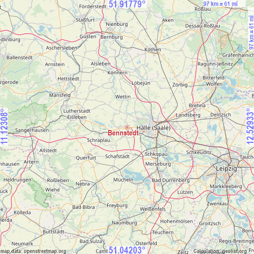
Bennstedt GPS coordinates[2]
51° 28' 55.236" North, 11° 49' 34.32" East
| Map corner | latitude | longitude |
|---|---|---|
| Upper-left | 51.91779°, | 11.12308° |
| Center: | 51.48201°, | 11.8262° |
| Lower-right: | 51.04203°, | 12.52933° |
| Map W x H: | 97.4×97.4 km | = 60.5×60.5mi |
| max Lat: | 55.01917° ⇑34% North |
| Bennstedt: | 51.48201° |
| min Lat: | ⇓66% South 47.40724° |
| min Long | Bennstedt | max Long |
| 5.92978° | 11.8262° | 14.98853° |
| W 79.2%⇐ | ⇒20.8% E |
Elevation
Elevation of Bennstedt is 90 m = 295 ft, and this is 159.1 m = 522 ft below average elevation for this country.
| Max E: |
1256 m = 4121 ft | 70.2% |
| Avg. | 249.1 m = 817 ft | |
| Bennstedt | 90 m = 295 ft | |
Min E: |
-5 m = -16 ft | 29.8% |
See also: Germany elevation on elevation.city.
Geographical zone
Bennstedt is located in North temperate zone (between Tropic of Cancer and the Arctic Circle). Distance of this North polar circle is 1676.9 km =1042 mi to North.| Distance of | km | miles | from Bennstedt |
|---|---|---|---|
| North Pole | 4282.8 | 2661.2 | to North |
| Arctic Circle | 1676.9 | 1042 | to North |
| Tropic Cancer | 3118.3 | 1937.6 | to South |
| Equator | 5724.3 | 3556.9 | to South |


Nearby cities:
15 places around Bennstedt: (largest is in red/bold)
• Amsdorf
7.1 km =4.4 mi,  254°
254°
• Angersdorf
6.1 km =3.8 mi,  113°
113°
• Brachwitz
6.8 km =4.2 mi,  25°
25°
• Halle Neustadt
6.2 km =3.9 mi,  92°
92°
• Holleben
6.8 km =4.2 mi,  132°
132°
• Höhnstedt
6.5 km =4 mi,  290°
290°
• Langenbogen
3.3 km =2.1 mi,  271°
271°
• Lieskau
3.5 km =2.2 mi,  45°
45°
• Salzmünde
5 km =3.1 mi,  0°
0°
• Schochwitz
7.4 km =4.6 mi,  318°
318°
• Steuden
8.1 km =5 mi,  210°
210°
• Teutschenthal
4 km =2.5 mi, 207°
• Wansleben
5.7 km =3.5 mi, 245°
• Zappendorf
3.8 km =2.4 mi,  325°
325°
• Zscherben
3.5 km =2.2 mi,  118°
118°
Sources, notices
• [Note1] Compared only with cities in Germany existing in our database
• [Src1] Map data: © OpenStreetMap contributors (CC-BY-SA)
• [Src2] Other city data from geonames.org with taken over terms of usage.
• [Src3] Geographical zone / Annual Mean Temperature by Robert A. Rohde @ Wikipedia
