Zappendorf geodata
Zappendorf (Saxony-Anhalt) is a populated place; located in Germany in Europe/Berlin (GMT+2) time zone. With population of 1,592 people, there are 5699 cities with bigger population in this country. Compared to other cities in Germany, 66.5% of cities are located further ↓South; 78.7% of cities are located further ←West and 70.4% of cities have higher elevation than Zappendorf. Note1


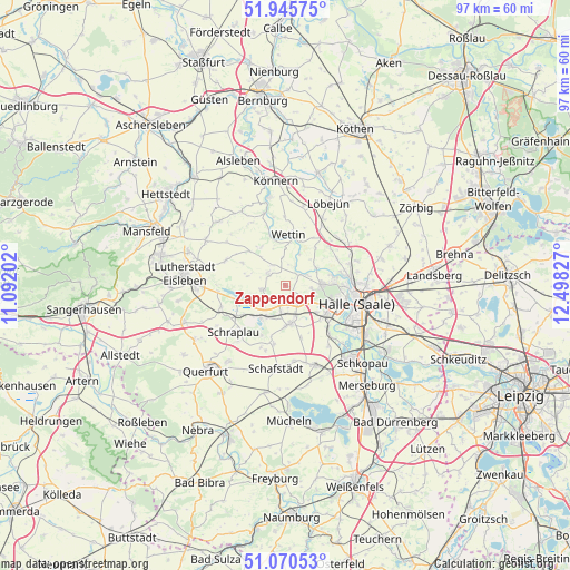
Zappendorf GPS coordinates[2]
51° 30' 36.864" North, 11° 47' 42.504" East
| Map corner | latitude | longitude |
|---|---|---|
| Upper-left | 51.94575°, | 11.09202° |
| Center: | 51.51024°, | 11.79514° |
| Lower-right: | 51.07053°, | 12.49827° |
| Map W x H: | 97.3×97.3 km | = 60.5×60.5mi |
| max Lat: | 55.01917° ⇑33.5% North |
| Zappendorf: | 51.51024° |
| min Lat: | ⇓66.5% South 47.40724° |
| min Long | Zappendorf | max Long |
| 5.92978° | 11.79514° | 14.98853° |
| W 78.7%⇐ | ⇒21.3% E |
Elevation
Elevation of Zappendorf is 89 m = 292 ft, and this is 160.1 m = 525 ft below average elevation for this country.
| Max E: |
1256 m = 4121 ft | 70.4% |
| Avg. | 249.1 m = 817 ft | |
| Zappendorf | 89 m = 292 ft | |
Min E: |
-5 m = -16 ft | 29.6% |
See also: Germany elevation on elevation.city.
Geographical zone
Zappendorf is located in North temperate zone (between Tropic of Cancer and the Arctic Circle). Distance of this North polar circle is 1673.8 km =1040.1 mi to North.| Distance of | km | miles | from Zappendorf |
|---|---|---|---|
| North Pole | 4279.7 | 2659.3 | to North |
| Arctic Circle | 1673.8 | 1040.1 | to North |
| Tropic Cancer | 3121.5 | 1939.6 | to South |
| Equator | 5727.4 | 3558.8 | to South |


Nearby cities:
15 places around Zappendorf: (largest is in red/bold)
• Amsdorf
6.9 km =4.3 mi,  222°
222°
• Beesenstedt
7.7 km =4.8 mi,  326°
326°
• Bennstedt
3.8 km =2.4 mi,  145°
145°
• Brachwitz
5.9 km =3.7 mi,  59°
59°
• Höhnstedt
4 km =2.5 mi,  257°
257°
• Kloschwitz
8.8 km =5.5 mi,  342°
342°
• Langenbogen
3.3 km =2.1 mi,  201°
201°
• Lieskau
4.7 km =2.9 mi,  98°
98°
• Salzmünde
2.8 km =1.7 mi,  49°
49°
• Schochwitz
3.7 km =2.3 mi,  310°
310°
• Seeburg
6.8 km =4.2 mi,  250°
250°
• Teutschenthal
6.7 km =4.2 mi,  177°
177°
• Wansleben
6.3 km =3.9 mi,  208°
208°
• Wettin
8.5 km =5.3 mi,  5°
5°
• Zscherben
7.1 km =4.4 mi,  132°
132°
Sources, notices
• [Note1] Compared only with cities in Germany existing in our database
• [Src1] Map data: © OpenStreetMap contributors (CC-BY-SA)
• [Src2] Other city data from geonames.org with taken over terms of usage.
• [Src3] Geographical zone / Annual Mean Temperature by Robert A. Rohde @ Wikipedia
